
Obrigado por apoiar este site ❤️
Faça uma doação
Faça uma doação
Mapa topográfico Battle Ground
Clique no mapa para exibir a altitude.
Obrigado por apoiar este site ❤️
Faça uma doação
Faça uma doação
Battle Ground
Battle Ground is located at 40°30′36″N 86°50′18″W / 40.51000°N 86.83833°W / 40.51000; -86.83833 (40.510110, −86.838220) in Tippecanoe Township, one and a quarter miles northwest of the Wabash River. Its elevation is approximately 585 feet. The small Harrison Creek begins near Battle Ground and flows east, while Burnett Creek skirts the town's western edge and flows southwest.
Obrigado por apoiar este site ❤️
Faça uma doação
Faça uma doação
Sobre este mapa
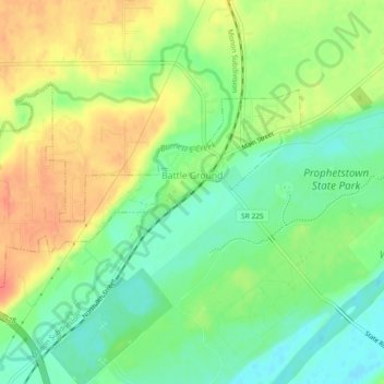
Nome: Mapa topográfico Battle Ground, altitude, relevo.
Altitude média: 180 m
Altitude mínima: 156 m
Altitude máxima: 208 m
Obrigado por apoiar este site ❤️
Faça uma doação
Faça uma doação
Outros mapas topográficos
Clique em um mapa para visualizar sua topografia, sua altitude e seu relevo.