
Faça uma doação
Mapa topográfico West Point
Clique no mapa para exibir a altitude.
Faça uma doação
Sobre este mapa
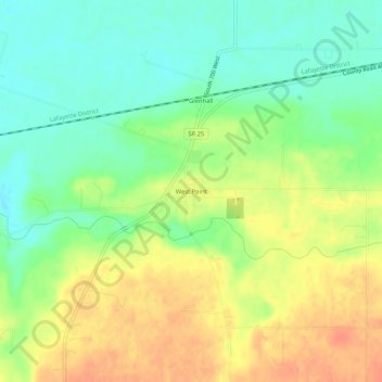
Nome: Mapa topográfico West Point, altitude, relevo.
Local: West Point, Tippecanoe County, Indiana, 47992, United States (40.32468 -87.06218 40.36468 -87.02218)
Altitude média: 198 m
Altitude mínima: 176 m
Altitude máxima: 222 m
Faça uma doação
Outros mapas topográficos
Clique em um mapa para visualizar sua topografia, sua altitude e seu relevo.
Dayton
United States > Indiana > Tippecanoe County
Dayton is located in northwest Sheffield Township, at an elevation of 676 feet (206 m).
Altitude média: 203 m
Battle Ground
United States > Indiana > Tippecanoe County
Battle Ground is located at 40°30′36″N 86°50′18″W / 40.51000°N 86.83833°W / 40.51000; -86.83833 (40.510110, −86.838220) in Tippecanoe Township, one and a quarter miles northwest of the Wabash River. Its elevation is approximately 585 feet. The small Harrison Creek begins near Battle…
Altitude média: 180 m
Faça uma doação