
Mapa topográfico Cannock Chase
Clique no mapa para exibir a altitude.
Sobre este mapa
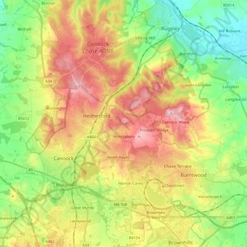
Nome: Mapa topográfico Cannock Chase, altitude, relevo.
Local: Cannock Chase, Staffordshire, England, United Kingdom (52.63968 -2.05464 52.77418 -1.91081)
Altitude média: 142 m
Altitude mínima: 61 m
Altitude máxima: 243 m
Outros mapas topográficos
Clique em um mapa para visualizar sua topografia, sua altitude e seu relevo.
College Gardens
United Kingdom > England > Staffordshire > Newcastle-under-Lyme > Madeley
Altitude média: 123 m
Tutbury Castle
United Kingdom > England > Staffordshire > East Staffordshire > Tutbury
Altitude média: 66 m
Burton upon Trent
United Kingdom > England > Staffordshire > East Staffordshire
Burton is about 109 miles (175 km) north west of London, about 30 miles north east of Birmingham, the UK's second largest city and about 23 miles east of the county town Stafford. It is at the easternmost border of the county of Staffordshire with Derbyshire, its suburbs and the course of the River Trent…
Altitude média: 69 m
Stubwood
United Kingdom > England > Staffordshire > East Staffordshire > Denstone
Altitude média: 113 m
Birch Cross
United Kingdom > England > Staffordshire > East Staffordshire > Marchington
Altitude média: 92 m
Biddulph Moor
United Kingdom > England > Staffordshire > Staffordshire Moorlands
Altitude média: 242 m
Wain Lea
United Kingdom > England > Staffordshire > Newcastle-under-Lyme > Harriseahead
Altitude média: 207 m
Weston Park
United Kingdom > England > Staffordshire > South Staffordshire > Weston under Lizard
Altitude média: 113 m
Stepping Stones
United Kingdom > England > Staffordshire > Staffordshire Moorlands
Altitude média: 224 m
Bottomhouse
United Kingdom > England > Staffordshire > Staffordshire Moorlands > Ipstones
Altitude média: 312 m
Apedale
United Kingdom > England > Staffordshire > Newcastle-under-Lyme > Chesterton
Altitude média: 168 m
Levedale
United Kingdom > England > Staffordshire > South Staffordshire > Penkridge
Altitude média: 98 m
Roughcote
United Kingdom > England > Staffordshire > Staffordshire Moorlands > Caverswall
Altitude média: 217 m
Blackshaw Moor
United Kingdom > England > Staffordshire > Staffordshire Moorlands > Thorncliffe
Altitude média: 282 m
Castle Ring
United Kingdom > England > Staffordshire > Cannock Chase > Cannock Wood
It is the highest point on The Chase with an elevation of 242 metres (794 ft).
Altitude média: 191 m
Newcastle-under-Lyme
United Kingdom > England > Staffordshire > Newcastle-under-Lyme
Altitude média: 147 m
Bignall End
United Kingdom > England > Staffordshire > Newcastle-under-Lyme > Audley
Altitude média: 150 m
Endon Bank
United Kingdom > England > Staffordshire > Staffordshire Moorlands > Endon
Altitude média: 192 m
Bednall
United Kingdom > England > Staffordshire > South Staffordshire > Bednall
Altitude média: 118 m
Blithfield Reservoir
United Kingdom > England > Staffordshire > East Staffordshire > Admaston
Altitude média: 108 m
Lower Lee
United Kingdom > England > Staffordshire > Staffordshire Moorlands > Meerbrook > Lower Lee
Altitude média: 264 m
Betley Mere
United Kingdom > England > Staffordshire > Borough of Newcastle-under-Lyme > Wrinehill > Cracow Moss
Altitude média: 81 m
Horton
United Kingdom > England > Staffordshire > Staffordshire Moorlands > Gratton
Altitude média: 199 m
Wood Lane
United Kingdom > England > Staffordshire > Newcastle-under-Lyme > Bignall Hill
Altitude média: 168 m
Rushton Spencer
United Kingdom > England > Staffordshire > Staffordshire Moorlands
Altitude média: 204 m
Calf Heath
United Kingdom > England > Staffordshire > South Staffordshire > Hatherton Junction
Altitude média: 113 m
Chasewater
United Kingdom > England > Staffordshire > Lichfield > Burntwood > Chasetown
Altitude média: 155 m
Old Hannah's Hole
United Kingdom > England > Staffordshire > Staffordshire Moorlands > Wetton
Altitude média: 276 m
Moneystone
United Kingdom > England > Staffordshire > Staffordshire Moorlands > Cotton
Altitude média: 231 m
Biddulph Grange Country Park
United Kingdom > England > Staffordshire > Staffordshire Moorlands > Biddulph > Biddulph Moor
Altitude média: 229 m
Moneystone Quarry
United Kingdom > England > Staffordshire > Staffordshire Moorlands > Kingsley > Whiston Eaves
Altitude média: 202 m
Rudyard Lake
United Kingdom > England > Staffordshire > Staffordshire Moorlands > Rudyard > Horton
Altitude média: 205 m
Hales Hall Pool
United Kingdom > England > Staffordshire > Staffordshire Moorlands > Cheadle
Altitude média: 182 m
Mottey Meadows NNR
United Kingdom > England > Staffordshire > South Staffordshire > Wheaton Aston
Altitude média: 110 m
Whiston
United Kingdom > England > Staffordshire > South Staffordshire > Penkridge
Altitude média: 95 m
Whitmore Heath
United Kingdom > England > Staffordshire > Newcastle-under-Lyme > Whitmore
Altitude média: 141 m
Birks Wood
United Kingdom > England > Staffordshire > Newcastle-under-Lyme > Shraleybrook
Altitude média: 109 m
Gratwich
United Kingdom > England > Staffordshire > East Staffordshire > Kingstone
Altitude média: 143 m