
Mapa topográfico Sayre
Mapa interativo
Clique no mapa para exibir a altitude.
Sobre este mapa
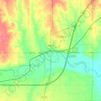
Nome: Mapa topográfico Sayre, altitude, relevo.
Local: Sayre, Beckham County, Oklahoma, 73662, United States (35.24766 -99.65779 35.33907 -99.59298)
Altitude média: 567 m
Altitude mínima: 536 m
Altitude máxima: 605 m
Sayre is located at 35°17′56″N 99°38′12″W / 35.29889°N 99.63667°W / 35.29889; -99.63667 (35.298940, -99.636556). It is located on the North Fork of the Red River, at an elevation of 1,800 feet (550 m) and 128 miles (206 km) west of Oklahoma City. The area is dominated by low rolling red clay hills.
Outros mapas topográficos
Clique em um mapa para visualizar sua topografia, sua altitude e seu relevo.
Texola
United States > Oklahoma > Beckham County
Texola, Beckham County, Oklahoma, 73668, United States
Altitude média: 654 m
Sweetwater
United States > Oklahoma > Beckham County
Sweetwater, Beckham County, Oklahoma, 73666, United States
Altitude média: 663 m
Erick
United States > Oklahoma > Beckham County
Erick, Beckham County, Oklahoma, 73645, United States
Altitude média: 631 m
Sayre
United States > Oklahoma > Beckham County > Sayre > Sayre
Sayre, Beckham County, Oklahoma, 73662, United States
Altitude média: 560 m
Elk City
United States > Oklahoma > Beckham County
Elk City, Beckham County, Oklahoma, United States
Altitude média: 588 m
Sayre
United States > Oklahoma > Beckham County
Sayre, Beckham County, Oklahoma, 73662, United States
Altitude média: 567 m