
Mapa topográfico Sayre
Mapa interativo
Clique no mapa para exibir a altitude.
Sobre este mapa
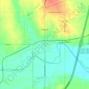
Nome: Mapa topográfico Sayre, altitude, relevo.
Local: Sayre, Beckham County, Oklahoma, 73662, United States (35.27116 -99.66010 35.31116 -99.62010)
Altitude média: 560 m
Altitude mínima: 541 m
Altitude máxima: 588 m
Sayre is located at 35°17′56″N 99°38′12″W / 35.29889°N 99.63667°W / 35.29889; -99.63667 (35.298940, -99.636556). It is located on the North Fork of the Red River, at an elevation of 1,800 feet (550 m) and 128 miles (206 km) west of Oklahoma City. The area is dominated by low rolling red clay hills.