
Obrigado por apoiar este site ❤️
Faça uma doação
Faça uma doação
Mapa topográfico Clipper Mills
Clique no mapa para exibir a altitude.
Obrigado por apoiar este site ❤️
Faça uma doação
Faça uma doação
Sobre este mapa
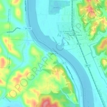
Nome: Mapa topográfico Clipper Mills, altitude, relevo.
Altitude média: 191 m
Altitude mínima: 164 m
Altitude máxima: 263 m
Obrigado por apoiar este site ❤️
Faça uma doação
Faça uma doação
Outros mapas topográficos
Clique em um mapa para visualizar sua topografia, sua altitude e seu relevo.
Gallipolis
United States > Ohio > Gallia County
Winters are cold, with an average January temperature of 34.3 °F (1.3 °C). Snowfall is generally very light, with a mean average snowfall of 10.9 inches (280 mm). The village does not experience by lake-effect snow, although the village's weather can be influenced by the Great Lakes and regional topography.…
Altitude média: 203 m
Obrigado por apoiar este site ❤️
Faça uma doação
Faça uma doação