Geolocalizar

Mapa topográfico Gallipolis

Mapa interativo

Clique no mapa para exibir a altitude.

Sobre este mapa

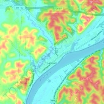
Nome: Mapa topográfico Gallipolis, altitude, relevo.

Local: Gallipolis, Gallia County, Ohio, United States (38.79311 -82.22809 38.83919 -82.14937)

Altitude média: 203 m

Altitude mínima: 165 m

Altitude máxima: 278 m

Winters are cold, with an average January temperature of 34.3 °F (1.3 °C). Snowfall is generally very light, with a mean average snowfall of 10.9 inches (280 mm). The village does not experience by lake-effect snow, although the village's weather can be influenced by the Great Lakes and regional topography. On average, there are 109 nights per year when the temperature drops to or below freezing, and only 14 days when the temperature fails to rise above freezing. Summers are hot and humid, with an average July temperature of 78.6 °F (25.9 °C). There are an average of 39 days per year with highs at or above 90 °F (32 °C).

Wikipedia (CC-BY-SA 3.0)

Outros mapas topográficos

Clique em um mapa para visualizar sua topografia, sua altitude e seu relevo.

Gallia County Fairgrounds

United States > Ohio > Gallia County

Gallia County Fairgrounds, Springfield Township, Gallia County, Ohio, 45631, United States

Altitude média: 200 m

Evergreen

United States > Ohio > Gallia County

Evergreen, Springfield Township, Gallia County, Ohio, 45614, United States

Altitude média: 219 m

Northup

United States > Ohio > Gallia County

Northup, Green Township, Gallia County, Ohio, United States

Altitude média: 204 m

Centerville

United States > Ohio > Gallia County

Centerville, Gallia County, Ohio, United States

Altitude média: 221 m

Rio Grande

United States > Ohio > Gallia County

Rio Grande, Gallia County, Ohio, United States

Altitude média: 209 m

Harrisburg

United States > Ohio > Gallia County

Harrisburg, Raccoon Township, Gallia County, Ohio, 45674, United States

Altitude média: 205 m

Mercerville

United States > Ohio > Gallia County

Mercerville, Guyan Township, Gallia County, Ohio, 45623, United States

Altitude média: 245 m

Porter

United States > Ohio > Gallia County

Porter, Springfield Township, Gallia County, Ohio, 45614, United States

Altitude média: 222 m

Bidwell

United States > Ohio > Gallia County

Bidwell, Springfield Township, Gallia County, Ohio, 45614, United States

Altitude média: 216 m

Adamsville

United States > Ohio > Gallia County

Adamsville, Raccoon Township, Gallia County, Ohio, 45674, United States

Altitude média: 203 m

Ewington

United States > Ohio > Gallia County

Ewington, Huntington Township, Gallia County, Ohio, 45686, United States

Altitude média: 210 m

Rodney

United States > Ohio > Gallia County

Rodney, Green Township, Gallia County, Ohio, United States

Altitude média: 215 m

Kanauga

United States > Ohio > Gallia County

Kanauga, Gallipolis Township, Gallia County, Ohio, 25106, United States

Altitude média: 187 m

Centerpoint

United States > Ohio > Gallia County

Centerpoint, Perry Township, Gallia County, Ohio, United States

Altitude média: 235 m

Gallia

United States > Ohio > Gallia County

Gallia, Greenfield Township, Gallia County, Ohio, United States

Altitude média: 224 m

Kerr

United States > Ohio > Gallia County

Kerr, Springfield Township, Gallia County, Ohio, 45614, United States

Altitude média: 205 m

Springfield Township

United States > Ohio > Gallia County

Springfield Township, Gallia County, Ohio, 45614, United States

Altitude média: 215 m

Vinton

United States > Ohio > Gallia County

Vinton, Gallia County, Ohio, 45686, United States

Altitude média: 207 m

Patriot

United States > Ohio > Gallia County

Patriot, Perry Township, Gallia County, Ohio, 45658, United States

Altitude média: 225 m

Cheshire

United States > Ohio > Gallia County

Cheshire, Gallia County, Ohio, United States

Altitude média: 180 m

Crown City

United States > Ohio > Gallia County

Crown City, Gallia County, Ohio, United States

Altitude média: 202 m

Bulaville

United States > Ohio > Gallia County

Bulaville, Addison Township, Gallia County, Ohio, United States

Altitude média: 206 m

Kyger

United States > Ohio > Gallia County

Kyger, Cheshire Township, Gallia County, Ohio, 45620, United States

Altitude média: 220 m