
Faça uma doação
Mapa topográfico Youngberg
Clique no mapa para exibir a altitude.
Faça uma doação
Sobre este mapa
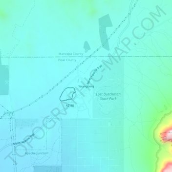
Nome: Mapa topográfico Youngberg, altitude, relevo.
Local: Youngberg, Pinal County, Arizona, United States (33.43894 -111.50735 33.47894 -111.46735)
Altitude média: 644 m
Altitude mínima: 574 m
Altitude máxima: 1.167 m
Faça uma doação
Outros mapas topográficos
Clique em um mapa para visualizar sua topografia, sua altitude e seu relevo.
Kearny
United States > Arizona > Pinal County
Kearny Airport is a general aviation airport located in the southern section of the town. In 2003 it received the Arizona Department of Transportation's Airport of the Year award. The airport has a single asphalt runway, 3,400 feet (1,000 m) in length and 60 feet (18 m) in width, with a field elevation of…
Altitude média: 578 m
Faça uma doação
Arizona City
United States > Arizona > Pinal County > Arizona City
Arizona City itself is mostly flat, lying in the Santa Cruz Valley in the center of three low mountain ranges; the Sawtooth Mountains to the south, the Picacho Mountains to the east, and the Casa Grande Mountains to the north. Picacho Peak, a prominent peak with a summit elevation of 3,374 feet (1,028 m), is…
Altitude média: 459 m
Faça uma doação
Superior
United States > Arizona > Pinal County
Superior has a hot semi-arid climate. In January, the average high temperature is 61 °F (16 °C) with a low of 43 °F (6 °C). In July, the average high temperature is 98 °F (37 °C) with a low of 76 °F (24 °C). Annual precipitation is just over 18 inches, but is higher at greater altitudes. Despite its…
Altitude média: 959 m
Maricopa
United States > Arizona > Pinal County
The topography in Maricopa is flat, with several mountain ranges 10 to 20 miles away. The elevation of Maricopa is 1190 feet.
Altitude média: 369 m
Faça uma doação
Queen Valley
United States > Arizona > Pinal County
Queen Valley is located at 33°17′42″N 111°17′52″W / 33.29500°N 111.29778°W / 33.29500; -111.29778, at an elevation of 2000 feet along the south side of the west flowing Queen Creek. The Tonto National Forest boundary and Comet Peak (2681 ft.) lie 1.5 miles to the east. The dam for the…
Altitude média: 633 m
Faça uma doação
Maricopa
United States > Arizona > Pinal County
The topography in Maricopa is flat, with several mountain ranges 10 to 20 miles away. The elevation of Maricopa is 1190 feet.
Altitude média: 369 m
Faça uma doação
Superior
United States > Arizona > Pinal County
Superior has a hot semi-arid climate. In January, the average high temperature is 61 °F (16 °C) with a low of 43 °F (6 °C). In July, the average high temperature is 98 °F (37 °C) with a low of 76 °F (24 °C). Annual precipitation is just over 18 inches, but is higher at greater altitudes. Despite its…
Altitude média: 959 m
Arizona City
United States > Arizona > Pinal County > Arizona City
Arizona City itself is mostly flat, lying in the Santa Cruz Valley in the center of three low mountain ranges; the Sawtooth Mountains to the south, the Picacho Mountains to the east, and the Casa Grande Mountains to the north. Picacho Peak, a prominent peak with a summit elevation of 3,374 feet (1,028 m), is…
Altitude média: 459 m
Faça uma doação