
Faça uma doação
Mapa topográfico Epping Forest
Clique no mapa para exibir a altitude.
Faça uma doação
Epping Forest
It lies on a ridge between the valleys of the rivers Lea and Roding. It contains areas of woodland, grassland, heath, streams, bogs, and ponds, and its elevation and thin gravelly soil (the result of glaciation) historically made it less suitable for agriculture. The forest was historically managed as a common; the land was held by a number of local landowners who exercised economic rights over aspects such as timber, while local commoners had grazing and other rights. It was designated a royal forest, meaning that only the monarch had the right to hunt deer.
Faça uma doação
Sobre este mapa
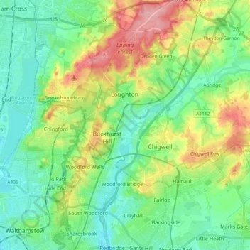
Nome: Mapa topográfico Epping Forest, altitude, relevo.
Altitude média: 44 m
Altitude mínima: 7 m
Altitude máxima: 121 m
Faça uma doação
Outros mapas topográficos
Clique em um mapa para visualizar sua topografia, sua altitude e seu relevo.
Roughtalley's Wood (South) & Epping Forest Woodland Burial Ground
United Kingdom > England > Essex > Epping Forest > Coopersale
Altitude média: 96 m
Faça uma doação
Nazeing Gate
United Kingdom > England > Essex > Epping Forest > Bumble's Green > Nazeing
Altitude média: 70 m
Faça uma doação
Passingford Bridge
United Kingdom > England > Essex > Epping Forest > Stapleford Tawney
Altitude média: 53 m
Faça uma doação
Thornwood Common
United Kingdom > England > Essex > Epping Forest > Thornwood Common
Altitude média: 89 m
Faça uma doação
Steward's Green
United Kingdom > England > Essex > Epping Forest > Coopersale Street > Steward's Green
Altitude média: 76 m
Faça uma doação
Faça uma doação
Passingford Bridge
United Kingdom > England > Essex > Epping Forest > Stapleford Tawney
Altitude média: 53 m