
Mapa topográfico Chigwell Row
Clique no mapa para exibir a altitude.
Sobre este mapa
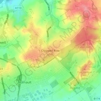
Nome: Mapa topográfico Chigwell Row, altitude, relevo.
Altitude média: 59 m
Altitude mínima: 19 m
Altitude máxima: 105 m
Outros mapas topográficos
Clique em um mapa para visualizar sua topografia, sua altitude e seu relevo.
Connaught Water
United Kingdom > England > Essex > Epping Forest > Sewardstonebury
Altitude média: 57 m
Roughtalley's Wood (South) & Epping Forest Woodland Burial Ground
United Kingdom > England > Essex > Epping Forest > Coopersale
Altitude média: 96 m
Epping Forest
United Kingdom > England > Essex > Epping Forest > Debden Green
It lies on a ridge between the valleys of the rivers Lea and Roding. It contains areas of woodland, grassland, heath, streams, bogs and ponds, and its elevation and thin gravelly soil (the result of glaciation) historically made it less suitable for agriculture. The Forest was historically managed as a common;…
Altitude média: 44 m
Stanford Rivers
United Kingdom > England > Essex > Epping Forest > Stanford Rivers
Altitude média: 65 m
Epping Forest
United Kingdom > England > Essex > Epping Forest > Debden Green
It lies on a ridge between the valleys of the rivers Lea and Roding. It contains areas of woodland, grassland, heath, streams, bogs, and ponds, and its elevation and thin gravelly soil (the result of glaciation) historically made it less suitable for agriculture. The forest was historically managed as a…
Altitude média: 44 m
Epping Forest
United Kingdom > England > Essex > Epping Forest
It lies on a ridge between the valleys of the rivers Lea and Roding. It contains areas of woodland, grassland, heath, streams, bogs, and ponds, and its elevation and thin gravelly soil (the result of glaciation) historically made it less suitable for agriculture. The forest was historically managed as a…
Altitude média: 44 m