
Faça uma doação
Mapa topográfico Crich CP
Clique no mapa para exibir a altitude.
Faça uma doação
Crich CP
The memorial tower ('Crich Stand') was completed in 1923 as a memorial to the 11,409 soldiers from the Sherwood Foresters Regiment who died in World War I, a dedication that was later extended to include World War II. It was built on an limestone outcrop above the village, at an altitude of 1,000 feet (300 m) above sea level. The location is symbolic because it is widely visible across, and gives views of, both of the two counties from which the regiment was raised (Nottinghamshire and Derbyshire). It is the destination of an annual pilgrimage on the first Sunday in July.
Faça uma doação
Sobre este mapa
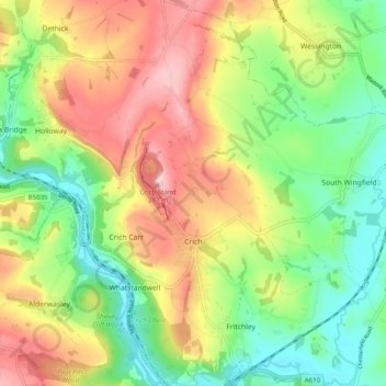
Nome: Mapa topográfico Crich CP, altitude, relevo.
Local: Crich CP, Amber Valley, Derbyshire, England, United Kingdom (53.06365 -1.50982 53.12288 -1.45672)
Altitude média: 159 m
Altitude mínima: 67 m
Altitude máxima: 278 m
Faça uma doação
Outros mapas topográficos
Clique em um mapa para visualizar sua topografia, sua altitude e seu relevo.
Alfreton Park
United Kingdom > England > Derbyshire > Amber Valley > Alfreton CP > Oakerthorpe
Altitude média: 116 m
Sawmills
United Kingdom > England > Derbyshire > Amber Valley > Ripley > Fritchley
Altitude média: 119 m
Faça uma doação