
Obrigado por apoiar este site ❤️
Faça uma doação
Faça uma doação
Mapa topográfico Langley Mill
Clique no mapa para exibir a altitude.
Obrigado por apoiar este site ❤️
Faça uma doação
Faça uma doação
Sobre este mapa
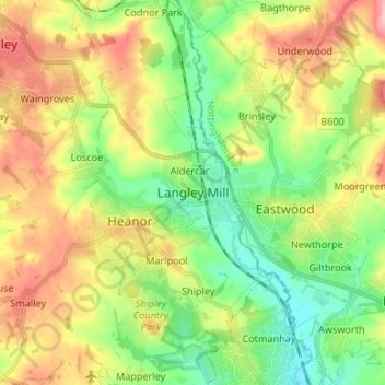
Nome: Mapa topográfico Langley Mill, altitude, relevo.
Altitude média: 100 m
Altitude mínima: 45 m
Altitude máxima: 177 m
Obrigado por apoiar este site ❤️
Faça uma doação
Faça uma doação
Outros mapas topográficos
Clique em um mapa para visualizar sua topografia, sua altitude e seu relevo.
Alfreton Park
United Kingdom > England > Derbyshire > Amber Valley > Alfreton CP > Oakerthorpe
Altitude média: 116 m
Crich CP
United Kingdom > England > Derbyshire > Amber Valley
The memorial tower ('Crich Stand') was completed in 1923 as a memorial to the 11,409 soldiers from the Sherwood Foresters Regiment who died in World War I, a dedication that was later extended to include World War II. It was built on an limestone outcrop above the village, at an altitude of 1,000 feet (300 m)…
Altitude média: 159 m
Obrigado por apoiar este site ❤️
Faça uma doação
Faça uma doação