
Faça uma doação
Mapa topográfico Hallstatt
Clique no mapa para exibir a altitude.
Faça uma doação
Hallstatt
The Hallstatt salt mine is the world's oldest working salt mine. The mine is located within the Upper Permian to Lower Triassic Haselgebirge Formation of the Northern Limestone Alps. The Hallstatt salt mine comprises 21 levels and several smaller shafts ranging from 514 metres (1,686 ft) above sea level (Erbstollen level) to an elevation of around 1,267 m (4,157 ft) (Erzherzog Matthias Schurf level).
Faça uma doação
Sobre este mapa
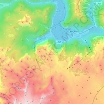
Nome: Mapa topográfico Hallstatt, altitude, relevo.
Local: Hallstatt, Bezirk Gmunden, Upper Austria, 4830, Austria (47.47500 13.55157 47.59373 13.67212)
Altitude média: 1.514 m
Altitude mínima: 501 m
Altitude máxima: 2.903 m
Faça uma doação
Outros mapas topográficos
Clique em um mapa para visualizar sua topografia, sua altitude e seu relevo.
Hoher Dachstein
Austria > Upper Austria > Bezirk Gmunden > Gosau
The Dachstein massif covers an area of around 600 square kilometres (230 sq mi) with dozens of peaks above 2,500 m, the highest of which are in the southern and southwestern areas. The main summit of the Hoher Dachstein is at an elevation of 2,997 metres (9,833 ft). Seen from the north, the Dachstein massif is…
Altitude média: 2.341 m
Faça uma doação
Predigstuhl
Austria > Upper Austria > Bezirk Gmunden > Bad Goisern am Hallstättersee
Altitude média: 921 m
Bad Goisern
Austria > Upper Austria > Bezirk Gmunden > Bad Goisern am Hallstättersee > Bad Goisern
Altitude média: 644 m
Faça uma doação
Faça uma doação