
Obrigado por apoiar este site ❤️
Faça uma doação
Faça uma doação
Mapa topográfico Hoher Dachstein
Clique no mapa para exibir a altitude.
Obrigado por apoiar este site ❤️
Faça uma doação
Faça uma doação
Hoher Dachstein
The Dachstein massif covers an area of around 600 square kilometres (230 sq mi) with dozens of peaks above 2,500 m, the highest of which are in the southern and southwestern areas. The main summit of the Hoher Dachstein is at an elevation of 2,997 metres (9,833 ft). Seen from the north, the Dachstein massif is dominated by glaciers with rocky summits rising beyond them. By contrast, to the south, the mountain drops almost vertically to the valley floor.
Obrigado por apoiar este site ❤️
Faça uma doação
Faça uma doação
Sobre este mapa
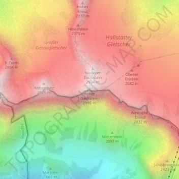
Nome: Mapa topográfico Hoher Dachstein, altitude, relevo.
Altitude média: 2.341 m
Altitude mínima: 1.579 m
Altitude máxima: 2.903 m
Obrigado por apoiar este site ❤️
Faça uma doação
Faça uma doação