
Faça uma doação
Mapa topográfico Butser Hill
Clique no mapa para exibir a altitude.
Faça uma doação
Sobre este mapa
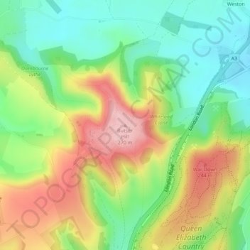
Nome: Mapa topográfico Butser Hill, altitude, relevo.
Altitude média: 164 m
Altitude mínima: 85 m
Altitude máxima: 269 m
Faça uma doação
Outros mapas topográficos
Clique em um mapa para visualizar sua topografia, sua altitude e seu relevo.
Rowlands Castle
United Kingdom > England > Hampshire > East Hampshire > Finchdean
Altitude média: 72 m
Faça uma doação
Faça uma doação
Rowland's Copse, Red Hill
United Kingdom > England > Hampshire > East Hampshire > Rowlands Castle
Altitude média: 42 m
Newton Valence
United Kingdom > England > Hampshire > East Hampshire
The village sits high in the westernmost chalk hills of the South Downs: maximum elevation 191 metres (627 feet) above sea level. Much of the surrounding landscape is within the East Hampshire Area of Outstanding Natural Beauty.
Altitude média: 153 m
Faça uma doação
Bramshott Common
United Kingdom > England > Hampshire > East Hampshire > Bramshott
Altitude média: 148 m
Faça uma doação
Havant Thicket
United Kingdom > England > Hampshire > East Hampshire > Rowlands Castle
Altitude média: 48 m
Ludshott Common
United Kingdom > England > Hampshire > East Hampshire > Bramshott
Altitude média: 162 m
Farringdon
United Kingdom > England > Hampshire > East Hampshire > Lower Farringdon
Altitude média: 153 m
Faça uma doação
Faça uma doação
Shalden
United Kingdom > England > Hampshire > East Hampshire
Shalden is a village and civil parish in the East Hampshire district of Hampshire, England. It is 2.3 miles (3.7 km) northwest of Alton and 1.9 miles (3.1 km) northeast of Bentworth, just off the A339 road. The parish covers an area of 1,536 acres (622 ha) and has an average elevation of 600 feet (180 m) above…
Altitude média: 177 m
Faça uma doação
Queen Elizabeth Country Park
United Kingdom > England > Hampshire > East Hampshire > Buriton
Altitude média: 151 m
Medstead
United Kingdom > England > Hampshire > East Hampshire
Medstead is a village and civil parish in the East Hampshire district of Hampshire, England. Its nearest town is Alton, which lies 4.3 miles (6.9 km) northeast of the village. According to the 2011 census, the village had a population of 2,036 people. The parish covers an area of 1,536 acres (622 ha) and has…
Altitude média: 186 m
Faça uma doação
Faça uma doação
Medstead
United Kingdom > England > Hampshire > East Hampshire
Medstead is a village and civil parish in the East Hampshire district of Hampshire, England. Its nearest town is Alton, which lies 4.3 miles (6.9 km) northeast of the village. According to the 2011 census, the village had a population of 2,036 people. The parish covers an area of 1,536 acres (622 ha) and has…
Altitude média: 186 m
Faça uma doação
Rowlands Castle
United Kingdom > England > Hampshire > East Hampshire > Finchdean
Altitude média: 72 m
Faça uma doação