
Mapa topográfico Medstead
Clique no mapa para exibir a altitude.
Medstead
Medstead is a village and civil parish in the East Hampshire district of Hampshire, England. Its nearest town is Alton, which lies 4.3 miles (6.9 km) northeast of the village. According to the 2011 census, the village had a population of 2,036 people. The parish covers an area of 1,536 acres (622 ha) and has an average elevation of approximately 600 feet (180 m) above sea level. One of the county's high points at 716 feet (218 m), King's Hill, runs through Medstead and Bentworth.
Sobre este mapa
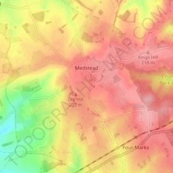
Nome: Mapa topográfico Medstead, altitude, relevo.
Local: Medstead, East Hampshire, Hampshire, England, United Kingdom (51.10494 -1.09543 51.14600 -1.03704)
Altitude média: 186 m
Altitude mínima: 114 m
Altitude máxima: 224 m
Outros mapas topográficos
Clique em um mapa para visualizar sua topografia, sua altitude e seu relevo.
Liphook
United Kingdom > England > Hampshire > East Hampshire
In Samuel Lewis's 1831 Topographical Dictionary of England, he referred to Liphook as a hamlet in the parish of Bramshott.
Altitude média: 121 m
Rowland's Copse, Red Hill
United Kingdom > England > Hampshire > East Hampshire > Rowlands Castle
Altitude média: 42 m
Hartley Mauditt
United Kingdom > England > Hampshire > East Hampshire > Hartley Mauditt
Altitude média: 123 m
Bramshott Common
United Kingdom > England > Hampshire > East Hampshire > Bramshott
Altitude média: 148 m
Havant Thicket
United Kingdom > England > Hampshire > East Hampshire > Rowlands Castle
Altitude média: 48 m
Ludshott Common
United Kingdom > England > Hampshire > East Hampshire > Bramshott
Altitude média: 162 m
Neatham
United Kingdom > England > Hampshire > East Hampshire > Alton > Holybourne
Altitude média: 122 m
Froxfield Green
United Kingdom > England > Hampshire > East Hampshire > High Cross
Altitude média: 177 m