
Faça uma doação
Mapa topográfico Lainach
Clique no mapa para exibir a altitude.
Faça uma doação
Sobre este mapa
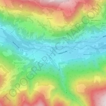
Nome: Mapa topográfico Lainach, altitude, relevo.
Altitude média: 1.171 m
Altitude mínima: 822 m
Altitude máxima: 1.729 m
Faça uma doação
Outros mapas topográficos
Clique em um mapa para visualizar sua topografia, sua altitude e seu relevo.
Pasterze
Austria > Carinthia > Bezirk Spittal an der Drau > Heiligenblut am Großglockner
Altitude média: 2.599 m
Millstatt am See
Austria > Carinthia > Bezirk Spittal an der Drau
It is situated on the southern slope of the Gurktal Alps (Nock Mountains), on an alluvial fan peninsula on the lake's northern shore. The municipal area reaches from an elevation of 588 m (1,929 ft) at the lakeside to 2,101 m (6,893 ft) AA at the crest of the Millstätter Alpe massif. It comprises the…
Altitude média: 1.149 m
Faça uma doação
Bad Kleinkirchheim
Austria > Carinthia > Bezirk Spittal an der Drau
Bad Kleinkirchheim is at an average elevation of 1,087 m (3,566 ft) in a 5 km (3 mi) stretch of a glacial trough valley in the Gurktal Alps (Nock Mountains), between the Millstätter See and the upper Gurk River. The populated section lies between 980 m (3,215 ft) and 1,380 m (4,528 ft), and the highest point…
Altitude média: 1.605 m
Faça uma doação
High Tauern National Park
Austria > Carinthia > Bezirk Spittal an der Drau > Heiligenblut am Großglockner
Altitude média: 1.710 m
Faça uma doação
Faça uma doação