
Faça uma doação
Mapa topográfico Mörtschach
Clique no mapa para exibir a altitude.
Faça uma doação
Sobre este mapa
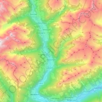
Nome: Mapa topográfico Mörtschach, altitude, relevo.
Local: Mörtschach, Bezirk Spittal an der Drau, Carinthia, Austria (46.87874 12.78295 46.98994 13.00216)
Altitude média: 1.851 m
Altitude mínima: 788 m
Altitude máxima: 3.239 m
Faça uma doação
Outros mapas topográficos
Clique em um mapa para visualizar sua topografia, sua altitude e seu relevo.
Großglockner
Austria > Carinthia > Bezirk Spittal an der Drau > Heiligenblut am Großglockner
The Glockner is the highest mountain in the Alps east of the Ortler range, about 175 km (109 mi) away, and, after Mont Blanc, has the second greatest topographic isolation of all mountains in the Alps. Even its topographic prominence, at 2,424 m (7,953 ft), is the second highest after Mont Blanc in the entire…
Altitude média: 3.128 m
Pasterze
Austria > Carinthia > Bezirk Spittal an der Drau > Heiligenblut am Großglockner
Altitude média: 2.599 m
Sankt Wolfgang
Austria > Carinthia > Bezirk Spittal an der Drau > Seeboden am Millstätter See > Seebach
Altitude média: 626 m
Faça uma doação
Untertauern
Austria > Carinthia > Bezirk Spittal an der Drau > Heiligenblut am Großglockner
Altitude média: 1.682 m
Großglockner
Austria > Carinthia > Bezirk Spittal an der Drau > Heiligenblut am Großglockner
The Glockner is the highest mountain in the Alps east of the Ortler range, about 175 km (109 mi) away, and, after Mont Blanc, has the second greatest topographic isolation of all mountains in the Alps. Even its topographic prominence, at 2,424 m (7,953 ft), is the second highest after Mont Blanc in the entire…
Altitude média: 3.128 m
Faça uma doação
Faça uma doação
Großglockner
Austria > Carinthia > Bezirk Spittal an der Drau > Heiligenblut am Großglockner
The Glockner is the highest mountain in the Alps east of the Ortler range, about 175 km (109 mi) away, and, after Mont Blanc, has the second greatest topographic isolation of all mountains in the Alps. Even its topographic prominence, at 2,424 m (7,953 ft), is the second highest after Mont Blanc in the entire…
Altitude média: 3.128 m
Faça uma doação
Heiligenblut
Austria > Carinthia > Bezirk Spittal an der Drau > Heiligenblut am Großglockner
Altitude média: 1.982 m
Faça uma doação
Hadergasse
Austria > Carinthia > Bezirk Spittal an der Drau > Heiligenblut am Großglockner
Altitude média: 1.677 m