
Faça uma doação
Mapa topográfico Magat Dam
Clique no mapa para exibir a altitude.
Faça uma doação
Sobre este mapa
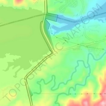
Nome: Mapa topográfico Magat Dam, altitude, relevo.
Local: Magat Dam, Isabela, Cagayan Valley, Philippines (16.80412 121.44780 16.83477 121.45784)
Altitude média: 175 m
Altitude mínima: 104 m
Altitude máxima: 294 m
Faça uma doação
Outros mapas topográficos
Clique em um mapa para visualizar sua topografia, sua altitude e seu relevo.
Ilagan
Abuan River is the main river of the Northern Sierra Madre Natural Park. It has an average elevation of 82 meters above sea level, and feeds the Abuan watershed in the city. Tourists and visitors can explore the diverse animal and plant life in one of the country’s remaining lush virgin forests. On January…
Altitude média: 123 m
Faça uma doação
Faça uma doação
Jones
Jones is primarily an agricultural municipality best suited for the intensive production of rice and corn as evidence by its topographic map which shows that 73% of the agricultural area of 16,848 hectares is under 0-3 slope category.
Altitude média: 99 m
Faça uma doação
Faça uma doação
Faça uma doação
San Mateo
The terrain of the municipality is basically plain with 98% of the total land area under 0-2 percent slope category and only 2% of the total area is under the 2.3-5 percent slope category. The excellent topography of the municipality has made irrigation by gravity method applicable in flooding of rice paddies.
Altitude média: 81 m
Faça uma doação
Faça uma doação
Faça uma doação
Faça uma doação
Roxas
The landscape of Roxas is relatively compose of flatlands with minimal rise at certain point with base mountain elevations on the eastern part, on the parts of Sinamar, Simimbaan and San Placido. It is approximately 90% of the land area comprising the town can be described as low-lying hills with rolling…
Altitude média: 59 m
Faça uma doação
Faça uma doação
Faça uma doação
Faça uma doação
Faça uma doação
Faça uma doação
Faça uma doação
Faça uma doação
Faça uma doação
Faça uma doação
Faça uma doação
Faça uma doação
Faça uma doação
Ilagan
Abuan River is the main river of the Northern Sierra Madre Natural Park. It has an average elevation of 82 meters above sea level, and feeds the Abuan watershed in the city. Tourists and visitors can explore the diverse animal and plant life in one of the country’s remaining lush virgin forests. On January…
Altitude média: 123 m
Faça uma doação
Faça uma doação
Ilagan
Abuan River is the main river of the Northern Sierra Madre Natural Park. It has an average elevation of 82 meters above sea level, and feeds the Abuan watershed in the city. Tourists and visitors can explore the diverse animal and plant life in one of the country’s remaining lush virgin forests. On January…
Altitude média: 123 m
Faça uma doação