
Faça uma doação
Mapa topográfico Ilagan
Clique no mapa para exibir a altitude.
Faça uma doação
Ilagan
Abuan River is the main river of the Northern Sierra Madre Natural Park. It has an average elevation of 82 meters above sea level, and feeds the Abuan watershed in the city. Tourists and visitors can explore the diverse animal and plant life in one of the country’s remaining lush virgin forests. On January 9, 2024, the city government of Ilagan ordered the temporary closure of Abuan River and its surrounding areas to all picnics and recreational activities to give way for its planned rehabilitation and development. On March 11, 2024, after more than a month since its closure, the officials of the city government led the reopening of the newly-rehabilitated tourist spot. It was later on rebranded and renamed as Abuan River Adventure and Eco-Tourism Park. Additional facilities/amenities for water adventure rides like kayaks, boats, jet-ski, All-Terrain Vehicles (ATVs), paragliding, LED/solar lights, steel cottages and comfort rooms were added to lure more local tourists and visitors from neighboring towns and provinces.
Faça uma doação
Sobre este mapa
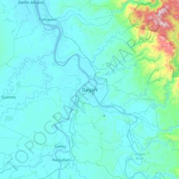
Nome: Mapa topográfico Ilagan, altitude, relevo.
Local: Ilagan, Isabela, Cagayan Valley, 3300, Philippines (16.98863 121.72865 17.30863 122.04865)
Altitude média: 123 m
Altitude mínima: 22 m
Altitude máxima: 1.091 m
Faça uma doação
Outros mapas topográficos
Clique em um mapa para visualizar sua topografia, sua altitude e seu relevo.
Faça uma doação
Faça uma doação
Faça uma doação
Faça uma doação