
Faça uma doação
Mapa topográfico Bekasi
Clique no mapa para exibir a altitude.
Faça uma doação
Bekasi
The City of Bekasi is a part of the Bekasi river basin, located in the downstream area of the basin with slopes ranging from 0 to 2% and elevations between 11 meters to 81 meters above sea level. The city of Bekasi is part of the Bekasi river basin and is located in the downstream area of the basin, with a slope ranging from 0 to 2% and elevations between 11 meters to 81 meters above sea level. This topographical condition leads to frequent flooding in many areas of Bekasi, especially during the rainy season, such as in the districts of Jatiasih, East Bekasi, Rawalumbu, South Bekasi, West Bekasi, and Pondok Melati.
Faça uma doação
Sobre este mapa
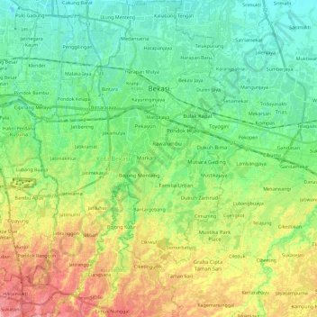
Nome: Mapa topográfico Bekasi, altitude, relevo.
Local: Bekasi, West Java, Java, Indonesia (-6.39860 106.89773 -6.17177 107.04247)
Altitude média: 32 m
Altitude mínima: -1 m
Altitude máxima: 91 m
Faça uma doação
Outros mapas topográficos
Clique em um mapa para visualizar sua topografia, sua altitude e seu relevo.
Bandung
Bandung (Sundanese: ᮘᮔ᮪ᮓᮥᮀ, romanized: Bandung, Sundanese pronunciation: [ˈbandʊŋ]; /ˈbɑːndʊŋ/) is the capital city of the Indonesian province of West Java. It has a population of 2,452,943 within its city limits according to the official estimates as at mid 2021, making it the fourth most…
Altitude média: 893 m
Faça uma doação
Faça uma doação
Faça uma doação
Non Block High Level Conference Monument Park
Indonesia > West Java > Bandung City > Arjuna
Altitude média: 731 m
Faça uma doação
Faça uma doação
Faça uma doação
Bekasi
The City of Bekasi is a part of the Bekasi river basin, located in the downstream area of the basin with slopes ranging from 0 to 2% and elevations between 11 meters to 81 meters above sea level. The city of Bekasi is part of the Bekasi river basin and is located in the downstream area of the basin, with a…
Altitude média: 23 m
Faça uma doação
Mount Galunggung
Indonesia > West Java > Tasikmalaya > Linggajati
One plane, a British Airways aircraft carrying 240 passengers and traveling from Kuala Lumpur, Malaysia, to Perth, Australia, on 24 June 1982, accidentally entered the ash cloud at night, about 150 km (93 mi; 81 nmi) downwind of the volcano. All four engines failed due to the buildup of volcanic ash, and the…
Altitude média: 1.286 m
Faça uma doação
Pangrango
Indonesia > West Java > Sukabumi
The Mandalawangi peak of the mountain is a tripoint where the borders of Bogor, Cianjur, and Sukabumi Regencies meet. It is the second-highest mountain in West Java after Mount Cereme. Mount Pangrango ranked 26th of the Ribus of Indonesia with a topographic prominence of 2,426 m (7,959 ft). The mountain is…
Altitude média: 2.491 m
Faça uma doação
Faça uma doação
Faça uma doação
Faça uma doação
Faça uma doação
Faça uma doação
Ngamprah
Indonesia > West Java > West Bandung
Ngamprah has an elevation moderated tropical rainforest climate (Af) with moderate rainfall from June to September and heavy rainfall from October to May.
Altitude média: 803 m
Ngamprah
Indonesia > West Java > West Bandung
Ngamprah has an elevation moderated tropical rainforest climate (Af) with moderate rainfall from June to September and heavy rainfall from October to May.
Altitude média: 803 m
Faça uma doação
Faça uma doação
DUSUN IV DESA MUKAPAYUNG KEC. CILILIN KAB. BANDUNG BARAT
Indonesia > West Java > West Bandung
Altitude média: 918 m
Faça uma doação
Faça uma doação
Faça uma doação
Faça uma doação
Faça uma doação
Faça uma doação
Faça uma doação
Faça uma doação
Faça uma doação