
Faça uma doação
Mapa topográfico Satriamekar
Clique no mapa para exibir a altitude.
Faça uma doação
Sobre este mapa
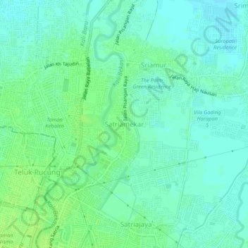
Nome: Mapa topográfico Satriamekar, altitude, relevo.
Local: Satriamekar, Kab Bekasi, West Java, Java, 17150, Indonesia (-6.21666 107.02502 -6.17666 107.06502)
Altitude média: 10 m
Altitude mínima: 4 m
Altitude máxima: 16 m
Faça uma doação
Outros mapas topográficos
Clique em um mapa para visualizar sua topografia, sua altitude e seu relevo.
Bekasi
The City of Bekasi is a part of the Bekasi river basin, located in the downstream area of the basin with slopes ranging from 0 to 2% and elevations between 11 meters to 81 meters above sea level. The city of Bekasi is part of the Bekasi river basin and is located in the downstream area of the basin, with a…
Altitude média: 32 m
Bandung City
Bandung (Sundanese: ᮘᮔ᮪ᮓᮥᮀ, romanized: Bandung, Sundanese pronunciation: [ˈbandʊŋ]; /ˈbɑːndʊŋ/) is the capital city of the Indonesian province of West Java. It has a population of 2,452,943 within its city limits according to the official estimates as at mid 2021, making it the fourth most…
Altitude média: 830 m
Faça uma doação
Faça uma doação
Faça uma doação
Faça uma doação
Faça uma doação
Faça uma doação
Non Block High Level Conference Monument Park
Indonesia > West Java > Bandung City > Arjuna
Altitude média: 731 m
Faça uma doação
Faça uma doação
Faça uma doação
Faça uma doação
Bogor
The city is situated in the western part of Java island, about 53 km south of the capital Jakarta and 85 km northwest of Bandung, the administrative center of West Java Province. Bogor spreads over a basin near volcanoes Salak, which peaks at about 12 km south, and Mount Gede whose top is 22–25 km south-east…
Altitude média: 310 m
Faça uma doação
Faça uma doação
Faça uma doação
Bekasi
The City of Bekasi is a part of the Bekasi river basin, located in the downstream area of the basin with slopes ranging from 0 to 2% and elevations between 11 meters to 81 meters above sea level. The city of Bekasi is part of the Bekasi river basin and is located in the downstream area of the basin, with a…
Altitude média: 32 m
Faça uma doação
Faça uma doação
Bogor
The city is situated in the western part of Java island, about 53 km south of the capital Jakarta and 85 km northwest of Bandung, the administrative center of West Java Province. Bogor spreads over a basin near volcanoes Salak, which peaks at about 12 km south, and Mount Gede whose top is 22–25 km south-east…
Altitude média: 310 m
Sukabumi
At an altitude of approximately 584 m (1,916 ft), the city is a minor hill station resort, with a cooler climate than the surrounding lowlands. The area around Sukabumi is also a popular destination for whitewater rafting. Tea and Rubber production is a major industry in the area. The suburban area surrounding…
Altitude média: 570 m
Faça uma doação
Faça uma doação
Faça uma doação
Faça uma doação
Bekasi
The City of Bekasi is a part of the Bekasi river basin, located in the downstream area of the basin with slopes ranging from 0 to 2% and elevations between 11 meters to 81 meters above sea level. The city of Bekasi is part of the Bekasi river basin and is located in the downstream area of the basin, with a…
Altitude média: 32 m
Bandung City
Bandung (Sundanese: ᮊᮧᮒ ᮘᮔ᮪ᮓᮥᮀ, romanized: Kota Bandung, pronounced [ˈbandʊŋ]; /ˈbɑːndʊŋ/) is the capital city of West Java province of Indonesia. Located on the island of Java, Greater Bandung (Bandung Basin Metropolitan Area / BBMA) is the country's second-largest and most populous…
Altitude média: 830 m
Cimahi
Cimahi, located 180 km south east of Jakarta, is situated between Bandung and West Bandung Regency. Cimahi comprises three districts (kecamatan), which in turn are sub-divided into fifteen urban villages (kelurahan). Its lowest elevation is 685 metres (2,247 ft) above sea level and directs to Citarum River.…
Altitude média: 779 m
Faça uma doação
Faça uma doação
Faça uma doação
Faça uma doação
Faça uma doação
Cisarua
The district is known for its mild climate, tea fields, and extensive views, being located at a rather high altitude. Near the district is a mountain pass known for its villas and hostels, as well as a well-known "heritage" hotel known as the "Puncak Pass", built in 1928.
Altitude média: 1.270 m
DUSUN IV DESA MUKAPAYUNG KEC. CILILIN KAB. BANDUNG BARAT
Indonesia > West Java > West Bandung
Altitude média: 918 m
Tasikmalaya
The city is located in the mountainous Priangan region of Java at an elevation of 351 metres (1,151 feet).
Altitude média: 367 m
Faça uma doação