
Faça uma doação
Mapa topográfico Dublin Castle
Clique no mapa para exibir a altitude.
Faça uma doação
Dublin Castle
The Poddle was diverted into the city through archways where the walls adjoined the castle, artificially flooding the moat of the fortress's city elevations. One of these archways and part of the wall survive buried underneath the 18th-century buildings, and are open for public viewing.
Faça uma doação
Sobre este mapa
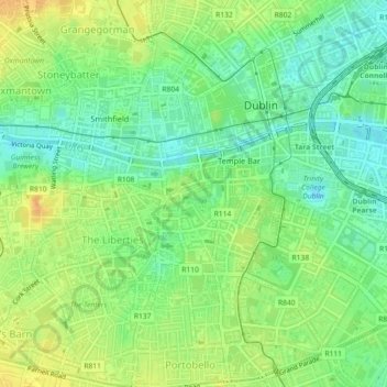
Nome: Mapa topográfico Dublin Castle, altitude, relevo.
Altitude média: 16 m
Altitude mínima: 1 m
Altitude máxima: 32 m
Faça uma doação
Outros mapas topográficos
Clique em um mapa para visualizar sua topografia, sua altitude e seu relevo.
Faça uma doação
Faça uma doação
Faça uma doação
Faça uma doação
Faça uma doação
Faça uma doação
Drimnagh Castle
Ireland > County Dublin > Dublin
By the mid-19th century, the castle was owned by the then Marquess of Lansdowne, with Samuel Lewis's Topographical Dictionary of Ireland (printed 1837) stating that it was an "irregular pile", the "property of the Marquess of Lansdowne [..] occupied by Mr. E. Cavanagh".
Altitude média: 45 m
Faça uma doação