
Faça uma doação
Mapa topográfico Starbase
Clique no mapa para exibir a altitude.
Faça uma doação
Starbase
SpaceX conducted a groundbreaking ceremony on the new launch facility in September 2014, and soil preparation began in October 2015. The first tracking antenna was installed in August 2016, and the first propellant tank arrived in July 2018. In late 2018, construction ramped up considerably, and the site saw the fabrication of the first 9 m-diameter (30 ft) prototype test vehicle, Starhopper, which was tested and flown March–August 2019. Through 2021, additional prototype flight vehicles were being built at the facility for higher-altitude tests. By late 2023, over 2,100 full-time employees were working at the site.
Faça uma doação
Sobre este mapa
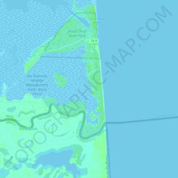
Nome: Mapa topográfico Starbase, altitude, relevo.
Altitude média: 2 m
Altitude mínima: -4 m
Altitude máxima: 11 m
Faça uma doação
Outros mapas topográficos
Clique em um mapa para visualizar sua topografia, sua altitude e seu relevo.
Faça uma doação
Faça uma doação
Valle Verde Colonia
United States > Texas > Cameron County > La Feria > Valle Verde Colonia
Altitude média: 19 m
Faça uma doação