
Mapa topográfico Urduliz
Mapa interativo
Clique no mapa para exibir a altitude.
Sobre este mapa
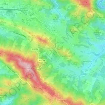
Nome: Mapa topográfico Urduliz, altitude, relevo.
Altitude média: 90 m
Altitude mínima: 0 m
Altitude máxima: 241 m
Outros mapas topográficos
Clique em um mapa para visualizar sua topografia, sua altitude e seu relevo.
Getxo
Spain > Autonomous Community of the Basque Country > Andraka
Getxo, Andraka, Biscay, Autonomous Community of the Basque Country, 48620, Spain
Altitude média: 36 m
Mungia
Spain > Autonomous Community of the Basque Country > Andraka
Mungia, Andraka, Biscay, Autonomous Community of the Basque Country, 48620, Spain
Altitude média: 111 m
Plentzia
Spain > Autonomous Community of the Basque Country > Andraka
Plentzia, Andraka, Biscay, Autonomous Community of the Basque Country, 48620, Spain
Altitude média: 61 m
Loiu
Spain > Autonomous Community of the Basque Country > Andraka
Loiu, Andraka, Biscay, Autonomous Community of the Basque Country, 48620, Spain
Altitude média: 70 m