
Faça uma doação
Mapa topográfico Getxo
Clique no mapa para exibir a altitude.
Faça uma doação
Sobre este mapa
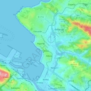
Nome: Mapa topográfico Getxo, altitude, relevo.
Local: Getxo, Bizkaia, Comunidade Autónoma do País Basco, Espanha (43.31987 -3.03962 43.38285 -2.96705)
Altitude média: 36 m
Altitude mínima: -3 m
Altitude máxima: 240 m
Faça uma doação
Outros mapas topográficos
Clique em um mapa para visualizar sua topografia, sua altitude e seu relevo.
Ambasaguas
Espanha > Comunidade Autónoma do País Basco > Karrantza Harana / Valle de Carranza
Altitude média: 246 m
Ambasaguas
Espanha > Comunidade Autónoma do País Basco > Karrantza Harana/Valle de Carranza
Altitude média: 246 m
Barria
Espanha > Comunidade Autónoma do País Basco > Arabako lautada/Llanada Alavesa
Altitude média: 614 m
Faça uma doação
Araia
Espanha > Comunidade Autónoma do País Basco > Arabako lautada/Llanada Alavesa
Altitude média: 676 m
Amezketa
Espanha > Comunidade Autónoma do País Basco > Tolosaldea > Amezketa > Amezketa
Altitude média: 345 m
Faça uma doação