
Faça uma doação
Mapa topográfico Mountain City
Clique no mapa para exibir a altitude.
Faça uma doação
Mountain City
Mountain City is an incorporated town in Rabun County, Georgia, United States. The population was 904 at the 2020 census. The town straddles the Eastern Continental Divide in a deep gap in the Blue Ridge Mountain front. The gap allows U.S. Route 441 to cross the range at an elevation of 2168 feet without the significant grade required by roadways at most other mountain passes along the Georgia Blue Ridge.
Faça uma doação
Sobre este mapa
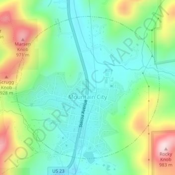
Nome: Mapa topográfico Mountain City, altitude, relevo.
Local: Mountain City, Rabun County, Georgia, 30562, United States (34.90855 -83.39892 34.93057 -83.37193)
Altitude média: 747 m
Altitude mínima: 635 m
Altitude máxima: 985 m
Faça uma doação
Outros mapas topográficos
Clique em um mapa para visualizar sua topografia, sua altitude e seu relevo.
Faça uma doação
Clayton
United States > Georgia > Rabun County > Clayton
According to the United States Census Bureau, the city has a total area of 3.1 square miles (8.0 km2), all of it land. The elevation of Clayton's downtown area is 1,925 feet (587 m). A number of hilltops within the city limits exceed 2,200 feet.
Altitude média: 634 m