
Mapa topográfico Zuidlaren
Mapa interativo
Clique no mapa para exibir a altitude.
Sobre este mapa
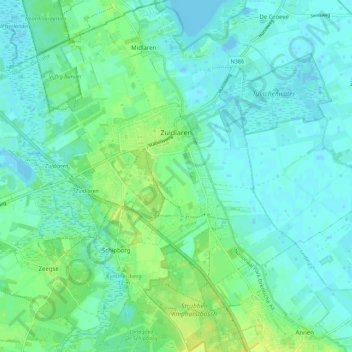
Nome: Mapa topográfico Zuidlaren, altitude, relevo.
Local: Zuidlaren, Tynaarlo, Drenthe, Netherlands (53.06517 6.63964 53.10652 6.75028)
Altitude média: 5 m
Altitude mínima: -4 m
Altitude máxima: 16 m
Outros mapas topográficos
Clique em um mapa para visualizar sua topografia, sua altitude e seu relevo.
Zuidbarge
Netherlands > Drenthe > Emmen
Zuidbarge, Emmen, Drenthe, Netherlands, 7825 TS, Netherlands
Altitude média: 20 m
Lhee
Lhee, Dwingeloo, Westerveld, Drenthe, Netherlands, 7991 PK, Netherlands
Altitude média: 11 m
De Kiel
Netherlands > Drenthe > Coevorden
De Kiel, Coevorden, Drenthe, Netherlands
Altitude média: 19 m
Nieuw-Buinen
Nieuw-Buinen, Borger-Odoorn, Drenthe, Netherlands
Altitude média: 7 m
Exloo
Netherlands > Drenthe > Borger-Odoorn
Exloo, Borger-Odoorn, Drenthe, Netherlands
Altitude média: 17 m