
Mapa topográfico Spier
Mapa interativo
Clique no mapa para exibir a altitude.
Sobre este mapa
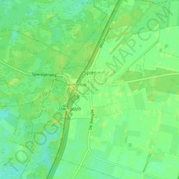
Nome: Mapa topográfico Spier, altitude, relevo.
Local: Spier, Midden-Drenthe, Drenthe, Netherlands (52.79589 6.45545 52.83496 6.49380)
Altitude média: 14 m
Altitude mínima: 7 m
Altitude máxima: 20 m
Outros mapas topográficos
Clique em um mapa para visualizar sua topografia, sua altitude e seu relevo.
Zuidbarge
Netherlands > Drenthe > Emmen
Zuidbarge, Emmen, Drenthe, Netherlands, 7825 TS, Netherlands
Altitude média: 20 m
Lhee
Lhee, Dwingeloo, Westerveld, Drenthe, Netherlands, 7991 PK, Netherlands
Altitude média: 11 m
De Kiel
Netherlands > Drenthe > Coevorden
De Kiel, Coevorden, Drenthe, Netherlands
Altitude média: 19 m
Nieuw-Buinen
Nieuw-Buinen, Borger-Odoorn, Drenthe, Netherlands
Altitude média: 7 m
Exloo
Netherlands > Drenthe > Borger-Odoorn
Exloo, Borger-Odoorn, Drenthe, Netherlands
Altitude média: 17 m