
Faça uma doação
Mapa topográfico Westwater
Clique no mapa para exibir a altitude.
Faça uma doação
Sobre este mapa
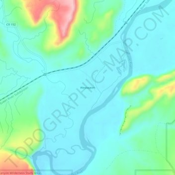
Nome: Mapa topográfico Westwater, altitude, relevo.
Local: Westwater, Grand County, Utah, United States (39.05832 -109.13233 39.09832 -109.09233)
Altitude média: 1.349 m
Altitude mínima: 1.307 m
Altitude máxima: 1.507 m
Faça uma doação
Outros mapas topográficos
Clique em um mapa para visualizar sua topografia, sua altitude e seu relevo.
Moab
United States > Utah > Grand County
Moab is just south of the Colorado River, at an elevation of 4,025 feet (1,227 m) on the Colorado Plateau. It is 18 miles (29 km) west of the Utah/Colorado state line. Via U.S. Route 191, it is 31 miles (50 km) south of Interstate 70 at Crescent Junction, and it is 54 miles (87 km) north of Monticello. Via…
Altitude média: 1.357 m
Delicate Arch
United States > Utah > Grand County
Delicate Arch is one of the main tourist draws in Arches National Park. The parking lot at the Delicate Arch Trailhead, although large, fills up quickly on most days. The trail to Delicate Arch is 3 miles (4.8 kilometer) round trip with an elevation change of 480 feet (146 meters). The trail is well defined…
Altitude média: 1.409 m
Arches National Park
United States > Utah > Grand County
The park consists of 310.31 square kilometres (76,680 acres; 119.81 sq mi; 31,031 ha) of high desert located on the Colorado Plateau. The highest elevation in the park is 5,653 feet (1,723 m) at Elephant Butte, and the lowest elevation is 4,085 feet (1,245 m) at the visitor center. The park receives an average…
Altitude média: 1.476 m
Faça uma doação
Arches National Park
United States > Utah > Grand County
The park consists of 310.31 square kilometres (76,680 acres; 119.81 sq mi; 31,031 ha) of high desert located on the Colorado Plateau. The highest elevation in the park is 5,653 feet (1,723 m) at Elephant Butte, and the lowest elevation is 4,085 feet (1,245 m) at the visitor center. The park receives an average…
Altitude média: 1.476 m
Moab
United States > Utah > Grand County
Moab is just south of the Colorado River, at an elevation of 4,025 feet (1,227 m) on the Colorado Plateau. It is 18 miles (29 km) west of the Utah/Colorado state line. Via U.S. Route 191, it is 31 miles (50 km) south of Interstate 70 at Crescent Junction, and it is 54 miles (87 km) north of Monticello. Via…
Altitude média: 1.357 m
Faça uma doação
Moab
United States > Utah > Grand County
Moab is just south of the Colorado River, at an elevation of 4,025 feet (1,227 m) on the Colorado Plateau. It is 18 miles (29 km) west of the Utah/Colorado state line. Via U.S. Route 191, it is 31 miles (50 km) south of Interstate 70 at Crescent Junction, and it is 54 miles (87 km) north of Monticello. Via…
Altitude média: 1.357 m
Delicate Arch
United States > Utah > Grand County
Delicate Arch is one of the main tourist draws in Arches National Park. The parking lot at the Delicate Arch Trailhead, although large, fills up quickly on most days. The trail to Delicate Arch is 3 miles (4.8 kilometer) round trip with an elevation change of 480 feet (146 meters). The trail is well defined…
Altitude média: 1.409 m