Geolocalizar

Mapa topográfico Delicate Arch

Mapa interativo

Clique no mapa para exibir a altitude.

Sobre este mapa

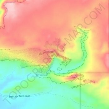
Nome: Mapa topográfico Delicate Arch, altitude, relevo.

Local: Delicate Arch, Delicate Arch Trail, Grand County, Utah, United States (38.74341 -109.49945 38.74353 -109.49913)

Altitude média: 1.409 m

Altitude mínima: 1.309 m

Altitude máxima: 1.490 m

Delicate Arch is one of the main tourist draws in Arches National Park. The parking lot at the Delicate Arch Trailhead, although large, fills up quickly on most days. The trail to Delicate Arch is 3 miles (4.8 kilometer) round trip with an elevation change of 480 feet (146 meters). The trail is well defined for the first 1/2 mile, then does a steep incline over open rock. There is a narrow ledge for the last 200 yards (183 meter) before reaching the arch.

Wikipedia (CC-BY-SA 3.0)

Outros mapas topográficos

Clique em um mapa para visualizar sua topografia, sua altitude e seu relevo.

Moab

United States > Utah > Grand County

Moab, Grand County, Utah, 84532, United States

Altitude média: 1.357 m

Westwater

United States > Utah > Grand County

Westwater, Grand County, Utah, United States

Altitude média: 1.349 m

Cisco

United States > Utah > Grand County

Cisco, Grand County, Utah, 84515, United States

Altitude média: 1.334 m

Rectory

United States > Utah > Grand County

Rectory, Grand County, Utah, United States

Altitude média: 1.527 m

Arches National Park

United States > Utah > Grand County

Arches National Park, Grand County, Utah, United States

Altitude média: 1.476 m

Thompson Springs

United States > Utah > Grand County

Thompson Springs, Grand County, Utah, 84540, United States

Altitude média: 1.583 m

Colorado River

United States > Utah > Grand County > Moab

Colorado River, Moab, Grand County, Utah, United States

Altitude média: 1.668 m

Castle Valley

United States > Utah > Grand County

Castle Valley, Grand County, Utah, United States

Altitude média: 1.610 m

Cottonwood Point

United States > Utah > Grand County

Cottonwood Point, Grand County, Utah, United States

Altitude média: 2.346 m

La Sal Mountains Viewpoint

United States > Utah > Grand County

La Sal Mountains Viewpoint, Main Park Road, Grand County, Utah, 84532-2134, United States

Altitude média: 1.347 m