
Mapa topográfico Ling Plantation
Clique no mapa para exibir a altitude.
Sobre este mapa
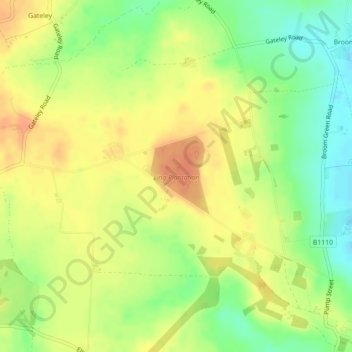
Nome: Mapa topográfico Ling Plantation, altitude, relevo.
Altitude média: 49 m
Altitude mínima: 26 m
Altitude máxima: 65 m
Outros mapas topográficos
Clique em um mapa para visualizar sua topografia, sua altitude e seu relevo.
Brettenham Heath - Open Access Land
United Kingdom > England > Norfolk > Breckland District > Brettenham
Altitude média: 40 m
Weasenham All Saints
United Kingdom > England > Norfolk > Breckland District > Weasenham
Altitude média: 71 m
North Tuddenham
United Kingdom > England > Norfolk > Breckland District > North Tuddenham
Altitude média: 41 m
Tittleshall
United Kingdom > England > Norfolk > Breckland District > Tittleshall
Altitude média: 69 m
Saham Hills
United Kingdom > England > Norfolk > Breckland District > Saham Toney
Altitude média: 61 m
Whissonsett
United Kingdom > England > Norfolk > Breckland District > Whissonsett
Altitude média: 67 m
Haverscroft Street
United Kingdom > England > Norfolk > Breckland District > Attleborough
Altitude média: 34 m
Sporle with Palgrave
United Kingdom > England > Norfolk > Breckland District > Sporle
Altitude média: 68 m
Stonebridge
United Kingdom > England > Norfolk > Breckland District > East Wretham
Altitude média: 38 m
Little Dunham
United Kingdom > England > Norfolk > Breckland District > Little Dunham
Altitude média: 79 m
Great Ellingham
United Kingdom > England > Norfolk > Breckland District > Great Ellingham
Altitude média: 43 m
Southburgh
United Kingdom > England > Norfolk > Breckland District > Cranworth > Southburgh
Altitude média: 55 m