
Faça uma doação
Mapa topográfico Daffy Green
Clique no mapa para exibir a altitude.
Faça uma doação
Sobre este mapa
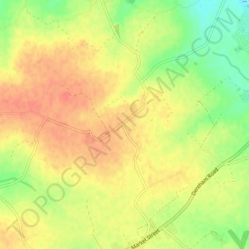
Nome: Mapa topográfico Daffy Green, altitude, relevo.
Altitude média: 71 m
Altitude mínima: 44 m
Altitude máxima: 90 m
Faça uma doação
Outros mapas topográficos
Clique em um mapa para visualizar sua topografia, sua altitude e seu relevo.
South Lopham
United Kingdom > England > Norfolk > Breckland District > South Lopham
Altitude média: 36 m
Brettenham Heath - Open Access Land
United Kingdom > England > Norfolk > Breckland District > Brettenham
Altitude média: 40 m
Faça uma doação
Weasenham All Saints
United Kingdom > England > Norfolk > Breckland District > Weasenham
Altitude média: 71 m
Faça uma doação
Faça uma doação
Faça uma doação
Faça uma doação
North Tuddenham
United Kingdom > England > Norfolk > Breckland District > North Tuddenham
Altitude média: 41 m
Faça uma doação
Tittleshall
United Kingdom > England > Norfolk > Breckland District > Tittleshall
Altitude média: 69 m
Faça uma doação
Faça uma doação
Whissonsett
United Kingdom > England > Norfolk > Breckland District > Whissonsett
Altitude média: 67 m
Faça uma doação
Sporle with Palgrave
United Kingdom > England > Norfolk > Breckland District > Sporle
Altitude média: 68 m
Faça uma doação
Faça uma doação
Faça uma doação
Faça uma doação
Little Dunham
United Kingdom > England > Norfolk > Breckland District > Little Dunham
Altitude média: 79 m
Great Ellingham
United Kingdom > England > Norfolk > Breckland District > Great Ellingham
Altitude média: 43 m
Faça uma doação
Faça uma doação
Faça uma doação
Faça uma doação
Faça uma doação
Faça uma doação
Faça uma doação
Faça uma doação