
Obrigado por apoiar este site ❤️
Faça uma doação
Faça uma doação
Mapa topográfico Netherne-on-the-Hill
Clique no mapa para exibir a altitude.
Obrigado por apoiar este site ❤️
Faça uma doação
Faça uma doação
Sobre este mapa
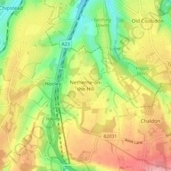
Nome: Mapa topográfico Netherne-on-the-Hill, altitude, relevo.
Altitude média: 153 m
Altitude mínima: 90 m
Altitude máxima: 218 m
Obrigado por apoiar este site ❤️
Faça uma doação
Faça uma doação
Outros mapas topográficos
Clique em um mapa para visualizar sua topografia, sua altitude e seu relevo.
Redhill Common
United Kingdom > England > Surrey > Reigate and Banstead > Redhill
Altitude média: 92 m
Banstead Wood
United Kingdom > England > Surrey > Reigate and Banstead > Chipstead
Altitude média: 145 m
Obrigado por apoiar este site ❤️
Faça uma doação
Faça uma doação
Horley
United Kingdom > England > Surrey > Reigate and Banstead
Horley is at an altitude of around 54 m (177 ft) above mean sea level.
Altitude média: 58 m
Lower Earlswood Lake
United Kingdom > England > Surrey > Reigate and Banstead > Redhill
Altitude média: 75 m