
Mapa topográfico Lower Earlswood Lake
Mapa interativo
Clique no mapa para exibir a altitude.
Sobre este mapa
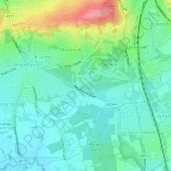
Nome: Mapa topográfico Lower Earlswood Lake, altitude, relevo.
Altitude média: 75 m
Altitude mínima: 49 m
Altitude máxima: 145 m
Outros mapas topográficos
Clique em um mapa para visualizar sua topografia, sua altitude e seu relevo.
St John's
United Kingdom > England > Surrey > Reigate and Banstead > Redhill
St John's, Meadvale, Redhill, Reigate and Banstead, Surrey, England, RH1 6QD, United Kingdom
Altitude média: 87 m
Redhill Common
United Kingdom > England > Surrey > Reigate and Banstead > Redhill
Redhill Common, Meadvale, Redhill, Reigate and Banstead, Surrey, England, United Kingdom
Altitude média: 92 m