
Mapa topográfico Carlton
Clique no mapa para exibir a altitude.
Sobre este mapa
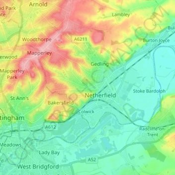
Nome: Mapa topográfico Carlton, altitude, relevo.
Altitude média: 51 m
Altitude mínima: 11 m
Altitude máxima: 130 m
Outros mapas topográficos
Clique em um mapa para visualizar sua topografia, sua altitude e seu relevo.
Gedling Country Park
United Kingdom > England > Nottinghamshire > Gedling > Carlton
Altitude média: 80 m
Lambley Lane Recreation Ground (North)
United Kingdom > England > Nottinghamshire > Gedling > Carlton
Altitude média: 73 m
Colwick Country Park
United Kingdom > England > Nottinghamshire > Gedling > Carlton > Colwick
Altitude média: 32 m