
Faça uma doação
Mapa topográfico Stoke Bardolph
Clique no mapa para exibir a altitude.
Faça uma doação
Sobre este mapa
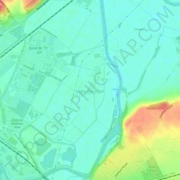
Nome: Mapa topográfico Stoke Bardolph, altitude, relevo.
Altitude média: 26 m
Altitude mínima: 10 m
Altitude máxima: 70 m
Faça uma doação
Outros mapas topográficos
Clique em um mapa para visualizar sua topografia, sua altitude e seu relevo.
Arnold
United Kingdom > England > Nottinghamshire > Gedling
The local topography suggests that Arnold can never have been a haunt of eagles, because they inhabit areas of rocky outcrops, which have formed cliffs: the nearest such location is Creswell Crags, some 20 miles (32 km) north-west as the eagle flies. However, the fish-eating white-tailed eagle (also known as…
Altitude média: 81 m
Gedling Country Park
United Kingdom > England > Nottinghamshire > Gedling > Carlton
Altitude média: 80 m
Faça uma doação
Colwick Country Park
United Kingdom > England > Nottinghamshire > Gedling > Carlton > Colwick
Altitude média: 32 m
Lambley Lane Recreation Ground (North)
United Kingdom > England > Nottinghamshire > Gedling > Carlton
Altitude média: 73 m