
Mapa topográfico Gatton
Clique no mapa para exibir a altitude.
Gatton
Gatton's elevations range from 215m AOD, the highest elevation, along Fort Lane, a cul-de-sac off the intersection of Reigate Hill (M25 Junction 8) which leads to four homes over the boundary in Reigate, a radio transmitter station, and a water tower. On the A217 is the Bridge House Hotel, whose name refers to a footbridge carrying the North Downs Way across the A217 85m to the east.
Sobre este mapa
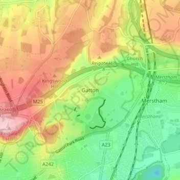
Nome: Mapa topográfico Gatton, altitude, relevo.
Altitude média: 134 m
Altitude mínima: 46 m
Altitude máxima: 236 m
Outros mapas topográficos
Clique em um mapa para visualizar sua topografia, sua altitude e seu relevo.
Lower Earlswood Lake
United Kingdom > England > Surrey > Reigate and Banstead > Redhill
Altitude média: 75 m
Redhill Common
United Kingdom > England > Surrey > Reigate and Banstead > Redhill
Altitude média: 92 m
Banstead Wood
United Kingdom > England > Surrey > Reigate and Banstead > Chipstead
Altitude média: 145 m
Horley
United Kingdom > England > Surrey > Reigate and Banstead
Horley is at an altitude of around 54 m (177 ft) above mean sea level.
Altitude média: 58 m