
Faça uma doação
Mapa topográfico Al Bad
Clique no mapa para exibir a altitude.
Faça uma doação
Sobre este mapa
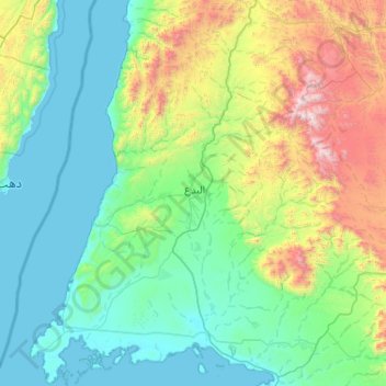
Nome: Mapa topográfico Al Bad, altitude, relevo.
Local: Al Bad, Tabuk Province, Saudi Arabia (28.02065 34.57103 28.92869 35.40483)
Altitude média: 483 m
Altitude mínima: -1 m
Altitude máxima: 2.512 m
Faça uma doação
Outros mapas topográficos
Clique em um mapa para visualizar sua topografia, sua altitude e seu relevo.
Jabal al Lawz
Between 1300 and 2200 meters elevation, Jabal al-Lawz has relict Mediterranean woodlands of Juniperus phoenicea, with an understory of Achillea santolinoides, Artemisia sieberi, and Astracantha echinus subsp. arabica.
Altitude média: 1.993 m
Jabal al Lawz
Between 1300 and 2200 meters elevation, Jabal al-Lawz has relict Mediterranean woodlands of Juniperus phoenicea, with an understory of Achillea santolinoides, Artemisia sieberi, and Astracantha echinus subsp. arabica.
Altitude média: 1.993 m
Faça uma doação
Neom
On 3 March 2022, Saudi Crown Prince Mohammed bin Salman launched the Trojena project, which will be the first major outdoor skiing destination in the Arabian Peninsula. It will be located about 50 kilometres (31 mi) from the Gulf of Aqaba coast, in the Sarwat Mountains, with elevations ranging from…
Altitude média: 52 m
Faça uma doação
Faça uma doação
Faça uma doação
Neom
On 3 March 2022, the Trojena project was launched, which will potentially be the first major outdoor skiing destination in the Arabian Peninsula. The project's site is about 50 kilometres (31 mi) from the Gulf of Aqaba coast in the Sarat Mountains, with elevations ranging from 1,500–2,600 metres…
Altitude média: 52 m
Faça uma doação