
Faça uma doação
Mapa topográfico Neom
Clique no mapa para exibir a altitude.
Faça uma doação
Neom
On 3 March 2022, the Trojena project was launched, which will potentially be the first major outdoor skiing destination in the Arabian Peninsula. The project's site is about 50 kilometres (31 mi) from the Gulf of Aqaba coast in the Sarat Mountains, with elevations ranging from 1,500–2,600 metres (4,900–8,500 ft). Although it is in the desert, the site's climate is considerably cooler than is the rest of Neom's territory. Ennismore, a lifestyle and hospitality company, was announced as the inaugural partner with its brands 25hours Hotels and Morgans Originals. In September 2023, Zaha Hadid Architects designed a 330 m (1,080 ft) tall skyscraper for Trojena which will stand on a mountain overlooking an artificial lake. Renders of the skyscraper, which will be connected to the lakeside development by a cable car, showed a crystalline structure made of numerous columns that narrow towards the peak.
Faça uma doação
Sobre este mapa
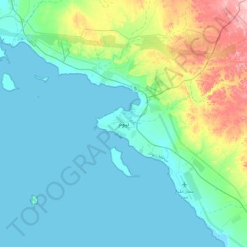
Nome: Mapa topográfico Neom, altitude, relevo.
Local: Neom, Tabuk Province, Saudi Arabia (27.84589 35.04270 28.16589 35.36270)
Altitude média: 52 m
Altitude mínima: -1 m
Altitude máxima: 283 m
Faça uma doação
Outros mapas topográficos
Clique em um mapa para visualizar sua topografia, sua altitude e seu relevo.
Faça uma doação
Faça uma doação
Faça uma doação
Faça uma doação
Faça uma doação