
Faça uma doação
Mapa topográfico Samaniego
Clique no mapa para exibir a altitude.
Faça uma doação
Sobre este mapa
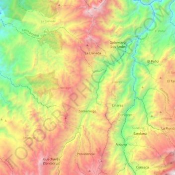
Nome: Mapa topográfico Samaniego, altitude, relevo.
Local: Samaniego, Los Abades, Nariño, RAP Pacífico, Colombia (1.18959 -77.88653 1.59577 -77.53816)
Altitude média: 1.837 m
Altitude mínima: 417 m
Altitude máxima: 3.847 m
Faça uma doação
Outros mapas topográficos
Clique em um mapa para visualizar sua topografia, sua altitude e seu relevo.
Galeras
Numerous minor tremors and ash emissions since March 2006 culminated on 12 July 2006 in three explosive eruptions, producing an ash and gas column reaching an altitude of 8 kilometres (5.0 mi). Rock falls and pyroclastic flows were reported from towns as distant as Consacá, 11.4 kilometres (7.1 mi) west of…
Altitude média: 3.847 m
Faça uma doação
Faça uma doação
Ipiales
Colombia > Nariño > Ipiales > Ipiales
Ipiales is a city and Catholic bishopric in Nariño Department, southern Colombia, near the border with Ecuador. It is located at around 0°49′49″N 77°38′40″W / 0.83028°N 77.64444°W / 0.83028; -77.64444, with an elevation of about 2950 m. Ipiales is located on the high plateau called…
Altitude média: 2.881 m
Pasto
Colombia > Nariño > Pasto > Pasto
Most of the city lies between 2,520 metres (8,270 ft) and 2,700 metres (8,900 ft) elevation above sea level, while some settlement exceeds 3,000 metres (9,800 ft) on the flanks of the Galeras Volcano, which stands at 4,276 metres (14,029 ft).
Altitude média: 2.668 m
Azufral
Azufral is a stratovolcano located in the department of Nariño in southern Colombia, 12 km (7 mi) west of the town of Túquerres. It is the only volcano of the Western Ranges of the Colombian Andes. Its name derives from the Spanish word for sulfur, azufre. The volcano is considered semi-dormant but there are…
Altitude média: 3.771 m
Faça uma doação