
Obrigado por apoiar este site ❤️
Faça uma doação
Faça uma doação
Mapa topográfico Pasto
Clique no mapa para exibir a altitude.
Obrigado por apoiar este site ❤️
Faça uma doação
Faça uma doação
Pasto
Most of the city lies between 2,520 metres (8,270 ft) and 2,700 metres (8,900 ft) elevation above sea level, while some settlement exceeds 3,000 metres (9,800 ft) on the flanks of the Galeras Volcano, which stands at 4,276 metres (14,029 ft).
Obrigado por apoiar este site ❤️
Faça uma doação
Faça uma doação
Sobre este mapa
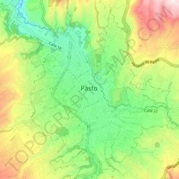
Nome: Mapa topográfico Pasto, altitude, relevo.
Local: Pasto, Centro, Nariño, Colombia (1.18024 -77.30949 1.24680 -77.24340)
Altitude média: 2.668 m
Altitude mínima: 2.357 m
Altitude máxima: 3.158 m
Obrigado por apoiar este site ❤️
Faça uma doação
Faça uma doação