
Faça uma doação
Mapa topográfico Newcastle upon Tyne
Clique no mapa para exibir a altitude.
Faça uma doação
Sobre este mapa
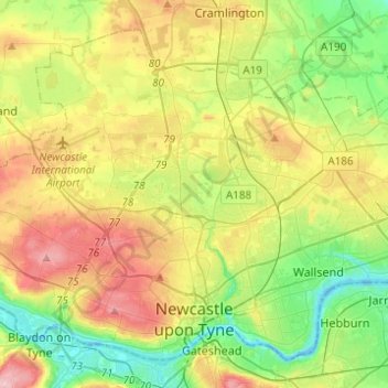
Nome: Mapa topográfico Newcastle upon Tyne, altitude, relevo.
Altitude média: 57 m
Altitude mínima: -4 m
Altitude máxima: 140 m
Faça uma doação
Outros mapas topográficos
Clique em um mapa para visualizar sua topografia, sua altitude e seu relevo.
South Shields
United Kingdom > England > Tyne and Wear > South Tyneside
The current town was founded in 1245 and developed as a fishing port. The name South Shields developed from the 'Schele' or 'Shield', which was a small dwelling used by fishermen. Another industry that was introduced, was that of salt-panning, later expanded upon in the 15th century, polluting the air and…
Altitude média: 23 m
Faça uma doação
Faça uma doação
Faça uma doação
Gateshead
United Kingdom > England > Tyne and Wear > Gateshead > Gateshead
One of the most distinguishing features of Gateshead is its topography. The land rises 230 feet from Gateshead Quays to the town centre and continues rising to a height of 525 feet at Queen Elizabeth Hospital in Sheriff Hill. This is in contrast to the flat and low lying Team Valley located on the western…
Altitude média: 62 m
West Herrington
United Kingdom > England > Tyne and Wear > Sunderland > New Herrington
Altitude média: 88 m
Faça uma doação
Faça uma doação
Faça uma doação
Faça uma doação
Faça uma doação
Faça uma doação
Faça uma doação
Smith's Dock
United Kingdom > England > Tyne and Wear > North Tyneside > North Shields
Altitude média: 21 m
Winlaton Mill Millennium Green
United Kingdom > England > Tyne and Wear > Gateshead > Winlaton Mill
Altitude média: 75 m
Faça uma doação
South Shields
United Kingdom > England > Tyne and Wear > South Tyneside
The current town was founded in 1245 and developed as a fishing port. The name South Shields developed from the 'Schele' or 'Shield', which was a small dwelling used by fishermen. Another industry that was introduced, was that of salt-panning, later expanded upon in the 15th century, polluting the air and…
Altitude média: 23 m
Faça uma doação
Faça uma doação
South Shields
United Kingdom > England > Tyne and Wear > South Tyneside
The current town was founded in 1245 and developed as a fishing port. The name South Shields developed from the 'Schele' or 'Shield', which was a small dwelling used by fishermen. Another industry that was introduced was that of salt-panning, later expanded upon in the 15th century, polluting the air and…
Altitude média: 23 m
Faça uma doação