
Mapa topográfico Gateshead
Clique no mapa para exibir a altitude.
Gateshead
One of the most distinguishing features of Gateshead is its topography. The land rises 230 feet (70 m) from Gateshead Quays to the town centre and continues rising to a height of 525 feet (160 m) at Queen Elizabeth Hospital in Sheriff Hill. This is in contrast to the flat and low lying Team Valley located on the western edges of town. The high elevations allow for impressive views over the Tyne valley into Newcastle and across Tyneside to Sunderland and the North Sea from lookouts in Windmill Hills and Windy Nook respectively.
Sobre este mapa
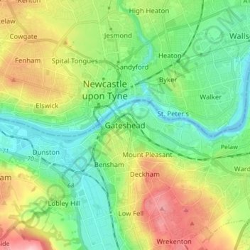
Nome: Mapa topográfico Gateshead, altitude, relevo.
Altitude média: 62 m
Altitude mínima: -5 m
Altitude máxima: 184 m