
Faça uma doação
Mapa topográfico Prunedale
Clique no mapa para exibir a altitude.
Faça uma doação
Prunedale
Prunedale is a unincorporated community in Monterey County, California, United States. It is located 8 miles (13 km) north of Salinas at an elevation of 92 feet (28 m). The population was 18,885 as of the 2020 census, up from 17,560 in 2010. For statistical purposes, the United States Census Bureau has defined Prunedale as a census-designated place (CDP). Plum trees were grown in Prunedale in the early days of its founding, but the trees died soon after due to poor irrigation and fertilizer.
Faça uma doação
Sobre este mapa
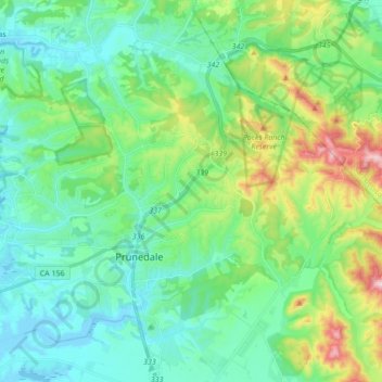
Nome: Mapa topográfico Prunedale, altitude, relevo.
Local: Prunedale, Monterey County, California, United States (36.74904 -121.74431 36.86844 -121.57276)
Altitude média: 104 m
Altitude mínima: -7 m
Altitude máxima: 430 m
Faça uma doação
Outros mapas topográficos
Clique em um mapa para visualizar sua topografia, sua altitude e seu relevo.
Faça uma doação
King City
United States > California > Monterey County
King City (variants: Kings City, City of King) is a city in Monterey County, California, United States. It is located on the Salinas River 51 miles (82 km) southeast of Salinas, at an elevation of 335 feet (102 m). It lies along U.S. Route 101 in the Salinas Valley of California's Central Coast. King City is a…
Altitude média: 93 m
Prunedale
United States > California > Monterey County > Prunedale
Prunedale is a census-designated place in Monterey County, California. Prunedale is located 8 miles (13 km) north of Salinas, at an elevation of 92 feet (28 m). The population was 17,560 residents at the time of the 2010 census, up from 16,432 at the 2000 census. Plum trees were grown in Prunedale in the early…
Altitude média: 69 m
Faça uma doação
Pajaro
United States > California > Monterey County > Pajaro
Pajaro (Spanish Pájaro 'bird') is an unincorporated community and census-designated place (CDP) in Monterey County, California. It is located on the south bank of the Pajaro River 5 miles (8 km) northeast of its mouth, at an elevation of 26 feet (7.9 m). The population was 2,882 at the 2020 census, down from…
Altitude média: 11 m
Bradley
United States > California > Monterey County
Bradley is an unincorporated community and census-designated place (CDP) in Monterey County, California, on the Salinas River 14 miles (23 km) south-southeast of San Ardo and 20 miles (32 km) north of Paso Robles. Bradley sits at an elevation of 548 feet (167 m). The population was 69 at the 2020 census, down…
Altitude média: 190 m
Faça uma doação
Del Rey Oaks
United States > California > Monterey County
Del Rey Oaks (Del Rey, Spanish for "Of the King") is a city in Monterey County, California, United States. It is located just southeast of Seaside, at an elevation of 82 feet (25 m). The population was 1,592 at the 2020 census. Del Rey Oaks is a member of the Association of Monterey Bay Area Governments, a…
Altitude média: 57 m
Faça uma doação
Faça uma doação
King City
United States > California > Monterey County
King City (variant: Kings City) is a city in Monterey County, California, United States. It is located on the Salinas River 51 miles (82 km) southeast of Salinas, at an elevation of 335 feet (102 m). It lies along U.S. Route 101 in the Salinas Valley of California's Central Coast. King City is a member of the…
Altitude média: 101 m
Las Lomas
United States > California > Monterey County
Las Lomas (Spanish for "The Hills") is an unincorporated community and census-designated place (CDP) in Monterey County, California, United States. Las Lomas is located 7 miles (11 km) north-northwest of Prunedale. The elevation is 43 feet (13 m). The population was 3,046 at the 2020 census.
Altitude média: 35 m
Greenfield
United States > California > Monterey County
Greenfield (formerly Clarke Colony) is a city in Monterey County, California, United States. It lies in the Salinas Valley, 33 miles (53 km) southeast of Salinas, at an elevation of 289 feet (88 m). As of the 2020 census, the population was 18,937, up from 16,330 in the 2010 census. Its most well-known public…
Altitude média: 86 m