
Faça uma doação
Mapa topográfico Thorpe Langton
Clique no mapa para exibir a altitude.
Faça uma doação
Sobre este mapa
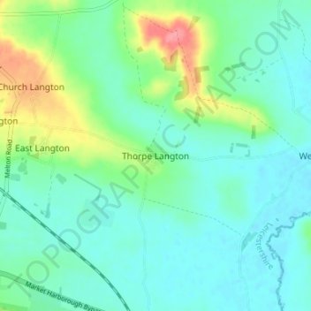
Nome: Mapa topográfico Thorpe Langton, altitude, relevo.
Altitude média: 86 m
Altitude mínima: 66 m
Altitude máxima: 148 m
Faça uma doação
Outros mapas topográficos
Clique em um mapa para visualizar sua topografia, sua altitude e seu relevo.
Adrian's Spinney
United Kingdom > England > Leicestershire > Harborough > Stoughton
Altitude média: 113 m
Faça uma doação
Illston on the Hill
United Kingdom > England > Leicestershire > Harborough > Illston on the Hill
Altitude média: 158 m
Faça uma doação
Faça uma doação
South Kilworth
United Kingdom > England > Leicestershire > Harborough > South Kilworth
Altitude média: 134 m
Broughton Astley
United Kingdom > England > Leicestershire > Harborough > Broughton Astley
Altitude média: 87 m
Faça uma doação
Faça uma doação
Kimcote and Walton
United Kingdom > England > Leicestershire > Harborough > Kimcote and Walton
Altitude média: 144 m
Faça uma doação
Little Stretton
United Kingdom > England > Leicestershire > Harborough > Little Stretton
Altitude média: 132 m
Faça uma doação
Claybrooke Magna
United Kingdom > England > Leicestershire > Harborough > Claybrooke Magna
Altitude média: 102 m
Faça uma doação
Stonton Wyville
United Kingdom > England > Leicestershire > Harborough > Stonton Wyville
Altitude média: 113 m
Burton Overy
United Kingdom > England > Leicestershire > Harborough > Burton Overy
Altitude média: 126 m
Faça uma doação
Saddington Reservoir
United Kingdom > England > Leicestershire > Harborough > Saddington
Altitude média: 128 m
Faça uma doação
Smeeton Westerby
United Kingdom > England > Leicestershire > Harborough > Smeeton Westerby
Altitude média: 112 m
Bruntingthorpe
United Kingdom > England > Leicestershire > Harborough > Bruntingthorpe
Altitude média: 132 m
Dunton Bassett
United Kingdom > England > Leicestershire > Harborough > Dunton Bassett
Altitude média: 115 m
Faça uma doação
Husbands Bosworth
United Kingdom > England > Leicestershire > Harborough > Husbands Bosworth
Altitude média: 142 m
Faça uma doação