
Mapa topográfico Gilmorton
Clique no mapa para exibir a altitude.
Sobre este mapa
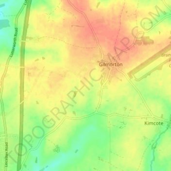
Nome: Mapa topográfico Gilmorton, altitude, relevo.
Local: Gilmorton, Harborough, Leicestershire, England, United Kingdom (52.46565 -1.19853 52.49676 -1.13339)
Altitude média: 136 m
Altitude mínima: 109 m
Altitude máxima: 156 m
Outros mapas topográficos
Clique em um mapa para visualizar sua topografia, sua altitude e seu relevo.
South Kilworth
United Kingdom > England > Leicestershire > Harborough > South Kilworth
Altitude média: 134 m
Broughton Astley
United Kingdom > England > Leicestershire > Harborough > Broughton Astley
Altitude média: 87 m
Kimcote and Walton
United Kingdom > England > Leicestershire > Harborough > Kimcote and Walton
Altitude média: 144 m
Little Stretton
United Kingdom > England > Leicestershire > Harborough > Little Stretton
Altitude média: 132 m
Claybrooke Magna
United Kingdom > England > Leicestershire > Harborough > Claybrooke Magna
Altitude média: 102 m
Stonton Wyville
United Kingdom > England > Leicestershire > Harborough > Stonton Wyville
Altitude média: 113 m
Burton Overy
United Kingdom > England > Leicestershire > Harborough > Burton Overy
Altitude média: 126 m
Smeeton Westerby
United Kingdom > England > Leicestershire > Harborough > Smeeton Westerby
Altitude média: 112 m
Bruntingthorpe
United Kingdom > England > Leicestershire > Harborough > Bruntingthorpe
Altitude média: 132 m
Dunton Bassett
United Kingdom > England > Leicestershire > Harborough > Dunton Bassett
Altitude média: 115 m
Halstead
United Kingdom > England > Leicestershire > Harborough > Tilton on the Hill > Halstead
Altitude média: 179 m
Husbands Bosworth
United Kingdom > England > Leicestershire > Harborough > Husbands Bosworth
Altitude média: 142 m