
Obrigado por apoiar este site ❤️
Faça uma doação
Faça uma doação
Mapa topográfico Groves
Clique no mapa para exibir a altitude.
Obrigado por apoiar este site ❤️
Faça uma doação
Faça uma doação
Groves
According to the United States Census Bureau, Groves has an area of 5.2 square miles (13.4 km2), of which 0.015 square miles (0.04 km2), or 0.28%, is water. Most of the city sits at an elevation of 5 to 15 feet (1.5 to 4.6 m) above sea level.
Obrigado por apoiar este site ❤️
Faça uma doação
Faça uma doação
Sobre este mapa
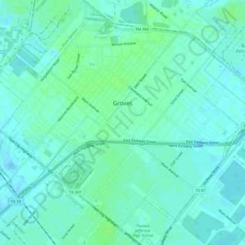
Nome: Mapa topográfico Groves, altitude, relevo.
Local: Groves, Jefferson County, Texas, 77619, United States (29.92488 -93.94477 29.96423 -93.89173)
Altitude média: 4 m
Altitude mínima: -2 m
Altitude máxima: 9 m
Obrigado por apoiar este site ❤️
Faça uma doação
Faça uma doação
Outros mapas topográficos
Clique em um mapa para visualizar sua topografia, sua altitude e seu relevo.