
Faça uma doação
Mapa topográfico Taklamakan Desert
Clique no mapa para exibir a altitude.
Faça uma doação
Sobre este mapa
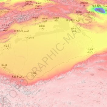
Nome: Mapa topográfico Taklamakan Desert, altitude, relevo.
Local: Taklamakan Desert, China (36.81423 77.49104 41.07188 89.77100)
Altitude média: 2.639 m
Altitude mínima: -154 m
Altitude máxima: 6.826 m
Faça uma doação
Outros mapas topográficos
Clique em um mapa para visualizar sua topografia, sua altitude e seu relevo.
Chongqing
The central urban area of Chongqing, or Chongqing proper, is a city of unique features. Built on mountains and partially surrounded by the Yangtze and Jialing rivers, it is known as a "mountain city" and a "city on rivers". The night scene of the city is very illuminated, with millions of lights and their…
Altitude média: 318 m
Faça uma doação
K2
China > Xinjiang > Cenling County
K2 is nicknamed "The King of Mountains" and "The Mountaineers' Mountain", as well as "The Mountain of Mountains", a phrase popularized by Italian climber Reinhold Messner in his book on K2. Although the summit of Everest is at a higher altitude, K2 is a more difficult and dangerous climb. This is in part due…
Altitude média: 7.482 m
Faça uma doação
Himalayas
The Himalayas, or Himalaya, is a mountain range in Asia separating the plains of the Indian subcontinent from the Tibetan Plateau. The range has some of the Earth's highest peaks, including the highest, Mount Everest. More than 100 peaks exceeding elevations of 7,200 metres (23,600 feet) above sea level lie in…
Altitude média: 2.385 m
Faça uma doação
Faça uma doação
Faça uma doação
Faça uma doação
Faça uma doação
Faça uma doação
Faça uma doação
Faça uma doação
Faça uma doação
Faça uma doação
Faça uma doação
Faça uma doação
Faça uma doação
Fanjing Mountain
China > Guizhou > Yinjiang Tujia and Miao Autonomous County
The Fanjingshan (Chinese: 梵净山; pinyin: Fànjìngshān) or Mount Fanjing, located in Tongren, Guizhou province, is the highest peak of the Wuling Mountains in southeastern China, at an elevation of 2,570 m (8,430 ft). The Fanjingshan National Nature Reserve was established in 1978 and designated a UNESCO…
Altitude média: 2.054 m
Faça uma doação
Faça uma doação
Tengchong
Situated at the southwestern end of the (transversely faulted) Hengduan Mountains, Tengchong topographically assumes the form of a horseshoe with the opening facing the south. The easternmost sources of the Irrawaddy River issue from the high mountains at the summit of Mount Danaozi of Gaoligong Mountain,…
Altitude média: 1.770 m
Faça uma doação
Faça uma doação
Tagong
A gompa is where the Tagong Monastery is located. The gompa is one of the most important in the in Tibetan Pel Lhagong. The Tagong Monastery was established with reference to a nearby sacred mountain, Mt. Yala or Zhara Lhaste, which is 5,820 metres (19,090 ft) in elevation.
Altitude média: 3.874 m
Junma Sichang Qilian
China > Gansu > Shandan County > Shandan horse breeding area
Altitude média: 2.558 m
Faça uma doação
Himalayas
The Himalayas, or Himalaya, is a mountain range in Asia separating the plains of the Indian subcontinent from the Tibetan Plateau. The range has some of the Earth's highest peaks, including the highest, Mount Everest. More than 100 peaks exceeding elevations of 7,200 m (23,600 ft) above sea level lie in the…
Altitude média: 2.385 m
Faça uma doação
Tai Mo Shan
Tai Mo Shan is the highest peak in Hong Kong, with an elevation of 957 metres (3,140 ft) above the Hong Kong Principal Datum [zh], or around 956 metres (3,136 ft) above mean sea level. It is located at approximately the geographical centre of the New Territories.
Altitude média: 600 m
Faça uma doação
Cho Oyu
China > Tibet > Tingri County
Cho Oyu's height was originally measured at 26,750 feet (8,150 m) and at the time of the first ascent it was considered the 7th highest mountain on earth, after Dhaulagiri at 8,167 metres (26,795 ft) (Manaslu, now 8,156 metres (26,759 ft), was also estimated lower at 26,658 feet (8,125 m)). A 1984 estimate of…
Altitude média: 7.339 m
Faça uma doação
Faça uma doação
Himalayas
The Himalayas, or Himalaya, is a mountain range in Asia separating the plains of the Indian subcontinent from the Tibetan Plateau. The range has some of the Earth's highest peaks, including the highest, Mount Everest. More than 100 peaks exceeding elevations of 7,200 m (23,600 ft) above sea level lie in the…
Altitude média: 2.385 m
Faça uma doação