
Faça uma doação
Mapa topográfico Tian Shan
Clique no mapa para exibir a altitude.
Faça uma doação
Tian Shan
The Torugart Pass, at 3,752 metres (12,310 ft), is located at the border between Kyrgyzstan and Xinjiang. The forested Alatau ranges, which are at a lower altitude in the northern part of the Tian Shan, are inhabited by Turkic-speaking pastoral tribes.
Faça uma doação
Sobre este mapa
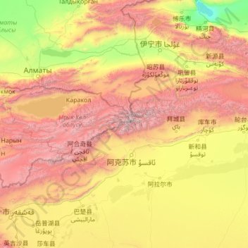
Nome: Mapa topográfico Tian Shan, altitude, relevo.
Local: Tian Shan, China (41.32734 76.33299 42.60164 85.12205)
Altitude média: 1.713 m
Altitude mínima: 193 m
Altitude máxima: 7.035 m
Faça uma doação
Outros mapas topográficos
Clique em um mapa para visualizar sua topografia, sua altitude e seu relevo.
Xinjiang
A semiarid or desert climate (Köppen BSk or BWk, respectively) prevails in Xinjiang. The entire region has great seasonal differences in temperature with cold winters. The Turpan Depression recorded the hottest temperatures nationwide in summer, with air temperatures easily exceeding 40 °C (104 °F). Winter…
Altitude média: 2.188 m
Beijing
Beijing is situated at the northern tip of the roughly triangular North China Plain, which opens to the south and east of the city. Mountains to the north, northwest and west shield the city and northern China's agricultural heartland from the encroaching desert steppes. The northwestern part of the…
Altitude média: 460 m
Faça uma doação
Chongqing
The central urban area of Chongqing, or Chongqing proper, is a city of unique features. Built on mountains and partially surrounded by the Yangtze and Jialing rivers, it is known as a "mountain city" and a "city on rivers". The night scene of the city is very illuminated, with millions of lights and their…
Altitude média: 318 m
Faça uma doação
Yunnan
Yunnan is situated in a mountainous area, with high elevations in the northwest and low elevations in the southeast. Most of the population lives in the eastern part of the province. In the west, the altitude can vary from the mountain peaks to river valleys by as much as 3,000 m (9,800 ft). Yunnan is rich in…
Altitude média: 1.713 m
Faça uma doação
Faça uma doação
Faça uma doação
Jilin
Jilin is highest in altitude in the southeast and drops gently towards the northwest. The Changbai Mountains run through its southeastern regions and contains the highest peak of the province, Paektu Mountain at 2,744 m (9,003 ft). Other ranges include the Jilinhada Mountains, Zhang Guangcai Mountains, and…
Altitude média: 352 m
Faça uma doação
Guiyang
Guiyang is the capital of Guizhou province in the People's Republic of China. It is centrally located within the province, on the eastern part of the Yunnan–Guizhou Plateau, and sits on the north bank of the Nanming River, a tributary of the Wu River. The city is situated at an elevation of approximately…
Altitude média: 1.209 m
Langzhong City
Langzhong is located in the northeast of the province and the northern part of the Sichuan Basin on the middle reaches of the Jialing River. Within the city's administrative area, elevations generally increase from southwest to northeast and range from 328 metres (1,076 ft) to 888 metres (2,913 ft), while…
Altitude média: 480 m
Faça uma doação
Faça uma doação
Faça uma doação
Liangshan
Owing to its low latitude and high elevation, Liangshan has a mild climate. Under the Köppen system, the prefecture belongs to the humid subtropical zone (Köppen Cwa). Winters feature mild days and cool nights, while summers are very warm and humid. Monthly daily mean temperatures range from 9.6 °C (49.3…
Altitude média: 2.434 m
Faça uma doação
Hebei
Hebei is the only province in China to contain plateaus, mountains, hills, shorelines, plains, and lakes. Most of central and southern Hebei lies within the North China Plain. Western Hebei rises into the Taihang Mountains (Taihang Shan), while the Yan Mountains (Yan Shan) runs through northern Hebei. Beyond…
Altitude média: 677 m
Faça uma doação
Faça uma doação
Kangding
Kangding has a monsoon-influenced climate, lying in the transition between a humid continental (Dwb) and a subtropical highland climate (Cwb) on the Köppen system. Despite the elevation of 2,560 metres (8,400 ft), the diurnal temperature variation averages at most 10.6 °C (19.1 °F) in any month. From April…
Altitude média: 3.331 m
Faça uma doação
Faça uma doação
Faça uma doação
Faça uma doação
Faça uma doação
Faça uma doação
Faça uma doação
Faça uma doação
Faça uma doação
Faça uma doação
Hong Kong
Hong Kong has a humid subtropical climate (Köppen Cwa), characteristic of southern China, despite being located south of the Tropic of Cancer. Summer is hot and humid, with occasional showers and thunderstorms and warm air from the southwest. Typhoons occur most often then, sometimes resulting in floods or…
Altitude média: 47 m
Shanghai
The golden age of Shanghai began with its elevation to municipality after it was separated from Jiangsu on 7 July 1927. This new Chinese municipality covered an area of 494.69 km2 (191.0 sq mi), including the modern-day districts of Baoshan, Yangpu, Zhabei, Nanshi, and Pudong, but excluded the foreign…
Altitude média: 12 m
Fanjing Mountain
China > Guizhou > Yinjiang Tujia and Miao Autonomous County
The Fanjingshan (Chinese: 梵净山; pinyin: Fànjìngshān) or Mount Fanjing, located in Tongren, Guizhou province, is the highest peak of the Wuling Mountains in southeastern China, at an elevation of 2,570 m (8,430 ft). The Fanjingshan National Nature Reserve was established in 1978 and designated a UNESCO…
Altitude média: 2.054 m
Faça uma doação
Faça uma doação
Yangtze
These tributaries join and the river then runs eastward through Qinghai (Tsinghai), turning southward down a deep valley at the border of Sichuan (Szechwan) and Tibet to reach Yunnan. In the course of this valley, the river's elevation drops from above 5,000 m (16,000 ft) to less than 1,000 m (3,300 ft). Thus,…
Altitude média: 426 m
Faça uma doação